

- Usage in publication:
-
- Slick Rock Member*
- Modifications:
-
- Named
- Dominant lithology:
-
- Sandstone
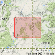
- AAPG geologic province:
-
- Piceance basin
- Paradox basin
Summary:
Named Upper Jurassic Slick Rock Member, middle member of Entrada Sandstone of San Rafael Group for town of Slick Rock, San Miguel Co, CO. Type section designated and measured in sec 36, T44N, R96W. Is present in Paradox and Piceance basins. Composed of brown or buff, light-reddish-brown, pink or salmon, very fine to fine-grained, moderately well sorted and rounded feldspathic sandstone. The medium to coarse, well-rounded, frosted sand-size grains called "Entrada berries." Bedding is massive in basal unit, cross-bedded in middle unit, and horizontally bedded in upper unit. Is 103 ft thick at type where it overlies Dewey Bridge Member and underlies Moab Member.
Source: GNU records (USGS DDS-6; Denver GNULEX).
For more information, please contact Nancy Stamm, Geologic Names Committee Secretary.
Asterisk (*) indicates published by U.S. Geological Survey authors.
"No current usage" (†) implies that a name has been abandoned or has fallen into disuse. Former usage and, if known, replacement name given in parentheses ( ).
Slash (/) indicates name conflicts with nomenclatural guidelines (CSN, 1933; ACSN, 1961, 1970; NACSN, 1983, 2005, 2021). May be explained within brackets ([ ]).