The National Geologic Map Database is migrating to a new infrastructure. We apologize for any service disruptions during this process.
|
|---|


- Usage in publication:
-
- Slatington shale
- Modifications:
-
- Original reference
- Dominant lithology:
-
- Shale
- AAPG geologic province:
-
- Ouachita folded belt
Summary:
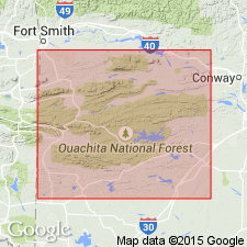
Pg. 557. Slatington shale. Shale unconformably overlying Blaylock sandstone and underlying Missouri Mountain formation [not Missouri Mountain slate but a younger formation]. Slatington shale and Misosuri Mountain formation may possibly be Silurian. [Apparently named from Slatington, Montgomery Co., AR. Recognized in southwestern AR and southeastern OK.]
[GNC remark (ca. 1936, US geologic names lexicon, USGS Bull. 896, p. 2011): †Slatington shale abandoned. The rocks are same as those named Missouri Mountain slate by Purdue later in 1909.]
Source: US geologic names lexicon (USGS Bull. 896, p. 2011).
For more information, please contact Nancy Stamm, Geologic Names Committee Secretary.
Asterisk (*) indicates published by U.S. Geological Survey authors.
"No current usage" (†) implies that a name has been abandoned or has fallen into disuse. Former usage and, if known, replacement name given in parentheses ( ).
Slash (/) indicates name conflicts with nomenclatural guidelines (CSN, 1933; ACSN, 1961, 1970; NACSN, 1983, 2005, 2021). May be explained within brackets ([ ]).