

- Usage in publication:
-
- Slabtown granite
- Modifications:
-
- First used
- Dominant lithology:
-
- [Granite]
- AAPG geologic province:
-
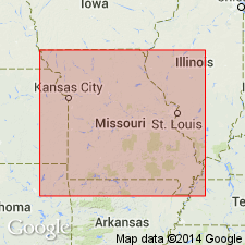
- Midcontinent region
Summary:
Slabtown granite (new) of Musco group (new). Briefly summarized in report by W.C. Hayes, Precambrian rock units in Missouri, p. 83 (table 1), this volume. New names are credited to Tolman and Robertson (in prep.) [1969, Missouri Div. Geol. Survey Water Res. Rpt. Inv., no. 44 (Contrib. to Precambrian Geol., no. 1)]. Age is Precambrian.
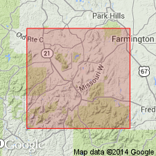
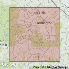
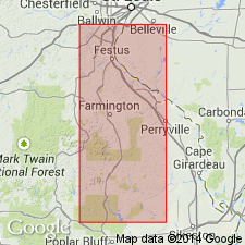
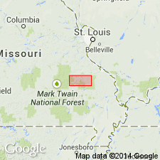
Occurs in St. Francois Mountain area. Slabtown Village is just northwest of Fredericktown, in T. 33 N., R. 6 E., Madison Co., southeastern MO.
Source: Modified from US geologic names lexicon (USGS Bull. 1350, p. 699).
- Usage in publication:
-
- Slabtown granite
- Modifications:
-
- Principal reference
- Dominant lithology:
-
- Granite
- AAPG geologic province:
-
- Midcontinent region
Summary:
Pg. 34. Slabtown granite of Musco group. A fine-grained granite, usually porphyritic, mottled pink and green. Phenocrysts and feldspar in groundmass are pink; fine-grained mafic minerals are distinctly green. As grain size of groundmass decreases, rocks usually appear to be more femic and take on brownish and purplish hues. In the coarser phases, mafic minerals show a distinct tendency to form in poorly defined clusters throughout the rock. Feldspar and quartz predominate and compose nearly 100 to rarely as little as 70 percent of the rock. Orthoclase microperthite varies from 40 to 60 percent, quartz 10 to 30 percent, and plagioclase accounts for about 10 percent of rock. Very similar to Stono granite (new) of Musco group. Weathers to dull buff to brown, blocky, tabular cobbles superficially resembling the weathered arkosic sandstone of the Lamotte formation. Exposed in St. Francois Mountains, southeastern Missouri, mostly in southeast part of T. 34 N., R. 6 E. Intruded by Silvermine granite of Bevos group. At Mount Devon, is host for diabase porphyry dike. Age is Precambrian.
Named from exposures southwest and east of Slabtown, in sec. 1, T. 33 N., R. 6 E., St. Francois Co., MO. (Type locality not designated.)
See C.E. Robertson, 1995, Precambrian rocks, IN T.L. Thompson, Stratigraphic succession in Missouri (revised-1995), Missouri Division of Geology and Land Survey, 2nd series, v. 40 Revised, p. 5-14.
[GNU remark (Feb. 16, 1990, USGS DDS-6; Denver GNULEX): Stratigraphic relationships of units of Musco not discussed in text; geologic map (plate 1) missing from library copy of report.]
Source: Strat. succession in Missouri (Thompson, 1995, p. 13); GNU records (USGS DDS-6; Denver GNULEX).
- Usage in publication:
-
- Slabtown Granite
- Modifications:
-
- Geochronologic dating
- AAPG geologic province:
-
- Midcontinent region
Summary:
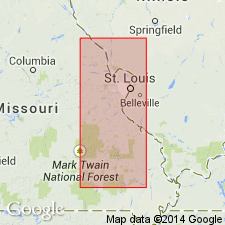
Rb-Sr age 1365 +/-50 m.y. determined on whole rock/mineral separates; U-Pb ages not determined. Rb-Sr ages on some rocks are consistently lower than U-Pb age probably due to removal of Sr from rock. Age of most rocks studied is about 1500 m.y., but a real event as recorded by Rb-Sr occurred about 1300 m.y. ago. Samples are taken from St. Francois Mountains, southeast MO, Midcontinent region.
Source: GNU records (USGS DDS-6; Denver GNULEX).
- Usage in publication:
-
- Slabtown Granite
- Modifications:
-
- Geochronologic dating
- AAPG geologic province:
-
- Midcontinent region
Summary:
Rb-Sr data on whole rock samples yields an age of 1321 +/-98 m.y. Rb-Sr data probably underestimates actual age; low age probably due to Sr loss. Samples taken in T34N, R6E, Madison Co, MO, Midcontinent region (specific localities listed in appendix 3). Analytical data in appendix 4.
Source: GNU records (USGS DDS-6; Denver GNULEX).
- Usage in publication:
-
- Slabtown Granite
- Modifications:
-
- Geochronologic dating
- AAPG geologic province:
-
- Midcontinent region
Summary:
Whole rock Rb-Sr age of 1321 +/-98 m.y. on Slabtown in St. Francois Mountains, MO, Midcontinent region.
Source: GNU records (USGS DDS-6; Denver GNULEX).

- Usage in publication:
-
- Slabtown Granite
- Modifications:
-
- Revised
- AAPG geologic province:
-
- Midcontinent region
Summary:
Slabtown Granite (referred to in table 1 as "Slabtown-Stono Granites"), one of seven Precambrian Y plutonic rock units assigned to the /St. Francois Mountains Intrusive Suite (revised). [Previously assigned to Musco Group by Tolman and Robertson (1969); status of Musco not discussed.] Present in St. Francois Mountains, southeast Missouri (Midcontinent region). Younger than "Butler Hill-Breadtray Granites" (revised) of St. Francois Mountains; older than "Silvermine-Knoblick Granites" (revised) of St. Francois Mountains. Age is Precambrian Y. Nomenclature listed in table 1.
[Conflicts with nomenclature guidelines (ACSN, 1970; NACSN, 1983, 2005, 2021): name St. Francois Mountains applied concurrently to two different units in same area; name Butler Hill applied concurrently to two different units in same area.]
Source: Modified from GNU records (USGS DDS-6; Denver GNULEX).
- Usage in publication:
-
- Slabtown granite
- Modifications:
-
- Overview
- AAPG geologic province:
-
- Midcontinent region
Summary:
Mapped in central St. Francois Mountains, southeast MO, Midcontinent region. [Not clear if authors intended stratigraphic units within study area to be formal or informal.] Exposed as fine-grained granite in several relatively small outcrops in southeastern part of mapped area; mapped undivided with low-silica plutons (which include Stono, Silvermine, Slabtown, and Knoblick Granites of Tolman and Robertson, 1969, and are mapped as "Ring Plutons of Butler Hill Caldera"). Low-silica plutons occur around margin of larger, high-silica Butler Hill granite (revised); contacts are not well enough exposed to determine intrusive relationships except that Butler Hill is intruded by Silvermine. Shown on map explanation to be younger than "Butler Hill-Breadtray Granite" map unit; older than "Hypabyssal Intrusives of Western St. Francois Mountains" map unit (which includes Munger Granite Porphyry and Carver Creek Granite of Tolman and Robertson, 1969). Everywhere that contacts are observed, plutonic rocks are younger than, and intrude, volcanic rocks of St. Francois Mountains. Proterozoic age.
[Authors' intentions are unclear as to which, if any, of the geologic units discussed should have formal status.]
Source: GNU records (USGS DDS-6; Denver GNULEX).
For more information, please contact Nancy Stamm, Geologic Names Committee Secretary.
Asterisk (*) indicates published by U.S. Geological Survey authors.
"No current usage" (†) implies that a name has been abandoned or has fallen into disuse. Former usage and, if known, replacement name given in parentheses ( ).
Slash (/) indicates name conflicts with nomenclatural guidelines (CSN, 1933; ACSN, 1961, 1970; NACSN, 1983, 2005, 2021). May be explained within brackets ([ ]).