

- Usage in publication:
-
- Skolai Group*
- Modifications:
-
- Named
- Reference
- Dominant lithology:
-
- Volcanics
- Volcaniclastics
- AAPG geologic province:
-
- Alaska Southern region
Summary:
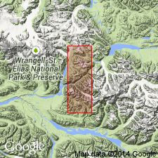
Named for thick sequence of low-grade metamorphic and predominantly volcanic and volcaniclastic exposures along upper reaches of Skolai Creek and Chitistone River. Name formerly used for "Skolai Volcanics" by Rohn (1900) which has been abandoned because rocks now included in Nikolai Greenstone and Wrangell Lava. Type area designated as area extending southeastward from near SW/4 sec.15 T2S R17E, Copper River Meridian to terminal moraine of Frederika Glacier, McCarthy C-4 quad, southern AK, where unit is more than 8000 ft thick. Reference section designated in secs.26-27, 33-35 T5S R18E, McCarthy B-4 quad where unit is more than 5500 ft thick (representing middle part of group). Divided into (ascending); Station Creek and Hasen Creek Formations (both new). Intruded by gabbro masses and sills. Unconformably underlies Nikolai Greenstone, Wrangell Lava, or Frederika Formation. Base not exposed. Age is Permian(?) and Permian based on paleontological evidence and stratigraphic relations.
Source: GNU records (USGS DDS-6; Menlo GNULEX).
- Usage in publication:
-
- Skolai Group*
- Modifications:
-
- Age modified
- AAPG geologic province:
-
- Alaska Southern region
Summary:
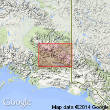
Age is Pennsylvanian and Early Permian based on correlation of Station Creek Formation with Middle Pennsylvanian to Early Permian Slana Spur Formation of Mankomen Group.
Source: GNU records (USGS DDS-6; Menlo GNULEX).
For more information, please contact Nancy Stamm, Geologic Names Committee Secretary.
Asterisk (*) indicates published by U.S. Geological Survey authors.
"No current usage" (†) implies that a name has been abandoned or has fallen into disuse. Former usage and, if known, replacement name given in parentheses ( ).
Slash (/) indicates name conflicts with nomenclatural guidelines (CSN, 1933; ACSN, 1961, 1970; NACSN, 1983, 2005, 2021). May be explained within brackets ([ ]).