

- Usage in publication:
-
- Sixmile Creek Formation*
- Modifications:
-
- Named
- Dominant lithology:
-
- Conglomerate
- Sandstone
- AAPG geologic province:
-
- Montana folded belt
Summary:
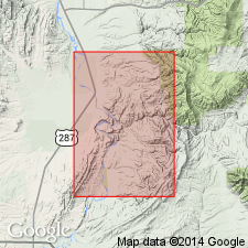
Named as uppermost formation of Bozeman Group for creek that flows westward from Big Belt Mountains and joins Missouri River 1 mi downstream (north) from Toston village. Exposures along Sixmile Creek in secs 9-15, T5N, R3E, Broadwater and Gallatin Cos, MT designated as type locality. Occurs in Montana folded belt province. Outcrops in central portion of quad from north to south edges of map. Consists of coarse, light-colored, tuffaceous, ridge-forming fanglomerate and shard-rich sandstone with subordinate stream silt, pond limestone, and air-laid rhyodacitic volcanic ash. In places unit divided into an upper rounded sand and gravel member, containing many stones of exotic metamorphic rocks, and a lower orange-red member consisting of fanglomerate and sandstone with orange-red clay matrix. Thickness of formation estimated to be not less than 4,000 ft in Dry Hollow and Sixmile Creek drainages, possibly reaching 6,000 ft farther north; in Clarkston Valley is about 2,000 ft thick. Disconformably overlies Dunbar Creek or Climbing Arrow Formations of Bozeman Group; overlies with angular unconformity pre-Tertiary rocks. Underlies thin Quaternary deposits with great erosional and angular unconformity. Cross sections. Previously mapped, though not named, in Townsend Valley by Pardee (1925) and in Duck Creek Pass quad by Nelson (1963). Age is early Miocene to late Pliocene on basis of vertebrate fossils [studied by E. Lewis, written communication].
Source: GNU records (USGS DDS-6; Denver GNULEX).
- Usage in publication:
-
- Sixmile Creek Formation
- Modifications:
-
- Revised
- Overview
- Areal extent
- AAPG geologic province:
-
- Montana folded belt
Summary:
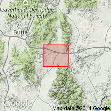
Extended into Jefferson basin area, southern Jefferson and northern Madison Cos, MT, Montana folded belt province, as upper of two formations of Bozeman Group. Crops out over 18 sq mi. Thickness is about 2,400 ft. Unconformably overlies Renova Formation (new) of Bozeman Group; unconformably underlies Quaternary deposits. Correlates with Madison Canyon Formation in Three Forks basin. Geologic map, cross sections, correlation chart, fossil list. Late Miocene (Barstovian) to middle Pliocene (Hemphillian) age based on vertebrate fossils.
Source: GNU records (USGS DDS-6; Denver GNULEX).
- Usage in publication:
-
- Sixmile Creek Formation
- Modifications:
-
- Age modified
- AAPG geologic province:
-
- Montana folded belt
Summary:
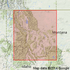
Assigned Barstovian to Hemphillian (middle and late Miocene) age based on fossil mammals (see correlation chart, fig 4, and appendix A). [North American land mammal ages (NALMA) are the same as reported by Kuenzi and Fields (1971), however, assignment of Barstovian to Hemphillian NALMAs to Miocene rather than Miocene and Pliocene is a modification.] Sixmile Creek occurs within Ruby River, Beaverhead, Jefferson River, and Three Forks basins, Toston area, and Townsend Valley (Montana folded belt province). In most areas unconformably overlies Renova Formation; underlies erosional pediment surface upon which quaternary sediments are deposited.
Source: GNU records (USGS DDS-6; Denver GNULEX).
- Usage in publication:
-
- Sixmile Creek Formation*
- Modifications:
-
- Not used
Summary:
Historical use of formal stratigraphic nomenclature applied to Bozeman Group in southwest MT, Montana folded belt province described. Charts. Bozeman and its formations --Sphinx Conglomerate (oldest), Milligan Creek, Climbing Arrow, Dunbar Creek, Sixmile Creek of the Toston-Clarkson Valley areas, and the Renova (oldest) and Sixmile Creek Formations of the Jefferson-Beaverhead Valley areas not used. These Tertiary rocks considered to be basin-fill deposits separable on basis of sequence stratigraphic concepts, rather than on lithostratigraphic principles. Lithologic distinctions within the group are not distinctive due to abrupt lateral facies changes. These rocks are separable into 5 sequences, numbered 1 to 5, no. 1 is the oldest, no. 5 is post-Bozeman alluvium. Each sequence is separated by an unconformity. Term unconformity applied in this paper to surfaces of non-deposition or erosion, these surfaces have soils developed on them. Sequence 1 consists of calc-alkalic flows, flow tuffs, tuff, matrix-supported conglomerate, some massive sandstone about 157 m thick, and is of Eocene age. Sequence 2 is mostly fluvial channel conglomerate, sandstone, mudstone, siltstone, and minor tuff, lapilli tuff about 400 m thick, and is of Eocene and Oligocene age. Sequence 3 is fluvial sheet sandstone, some mudstone, siltstone, sandstone, lenses of conglomerate of flood plain origin about 214 m thick, and is of Oligocene and Miocene age. Sequence 4 is mudstone, siltstone, sandstone, lenses of conglomerate mostly of flood plain origin 1,000 m thick, and is of Miocene and Pliocene age. Sequence 5 unconformably overlies rocks that were assigned to Bozeman. Map shows distribution of the 5 sequences. The unconformities can be traced into the subsurface seismically.
Source: GNU records (USGS DDS-6; Denver GNULEX).
- Usage in publication:
-
- Sixmile Creek Formation
- Modifications:
-
- Not used
Summary:
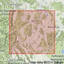
Bozeman Group of Eocene to Pliocene age is mapped as an undivided unit with some unnamed Tertiary valley-fill deposits. Although Bozeman has been divided into the Sixmile Creek and Renova Formations mainly on the basis of mammalian fauna, these formation names are not used in the Dillon quad because they cannot be separated lithologically at most localities in this quad. Mapped on both sides of Jefferson and Ruby Rivers in the eastern part of the quad, in the south-central and southwest and west-central parts of the map area, Madison and Beaverhead Cos, MT in the Montana folded belt province. Map unit is more than 4000 m thick.
Source: GNU records (USGS DDS-6; Denver GNULEX).
For more information, please contact Nancy Stamm, Geologic Names Committee Secretary.
Asterisk (*) indicates published by U.S. Geological Survey authors.
"No current usage" (†) implies that a name has been abandoned or has fallen into disuse. Former usage and, if known, replacement name given in parentheses ( ).
Slash (/) indicates name conflicts with nomenclatural guidelines (CSN, 1933; ACSN, 1961, 1970; NACSN, 1983, 2005, 2021). May be explained within brackets ([ ]).