

- Usage in publication:
-
- Singleshot member
- Modifications:
-
- First used
- Dominant lithology:
-
- Argillite
- Quartzite
- Sandstone
- AAPG geologic province:
-
- Northern Rocky Mountain region
Summary:
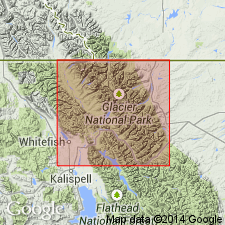
First published use as basal member of three members of Appekunny formation of Ravalli group of Belt series. Intent to name not stated. No type locality designated. Source of geographic name is probably Singleshot Mountain [though not stated] near St. Mary Lake, eastern Glacier National Park, MT in the Northern Rocky Mountain region. Is 300-400 ft thick in a generalized section compiled from information on rocks south of Ahern Pass in Lewis Range and in Boulder Pass, Clark Range and Waterton Lakes National Park, AT and BC, CN. [Not possible to determine exact areal extent.] Composed of meta-argillite interbedded with quartzite and dolomite sandstone. Rocks range from brown to green and white to red. Mud cracks and coarse ripple marks common. Overlies Altyn formation. Underlies Appistoki member (first used) of Appekunny. Of Algonkian, Proterozoic age.
Source: GNU records (USGS DDS-6; Denver GNULEX).

- Usage in publication:
-
- Singleshot member
- Modifications:
-
- Overview
- AAPG geologic province:
-
- Northern Rocky Mountain region
Summary:
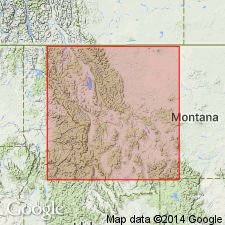
Is the basal member of Appekunny formation of Ravalli group of Belt series. Type locality (none designated in earlier paper) stated to be at Singleshot Mountain near St. Mary Lake, Glacier National Park, MT, Northern Rocky Mountain region. A section 375 ft thick west of Waterton Lake includes 300 ft of argillite and quartzite which weather red and gray interbedded with lesser amount of buff, dolomitic sandstone, and grit, mud cracks and ripple marks common at base, and an overlying buff, siliceous, thin- to medium-bedded 75 ft dolomite. A coarser phase with no dolomite that is 775 ft thick present in Galton Range. Is younger than Altyn formation of Ravalli. Is older than Appistoki member of Appekunny. Of pre-Cambrian age. Correlation chart.
Source: GNU records (USGS DDS-6; Denver GNULEX).
- Usage in publication:
-
- Singleshot member
- Modifications:
-
- Not used
Summary:
Cannot be traced for enough to be valid as a formally named unit (member of Appekunny formation). Fenton and Fenton (1937) divisions of Appekunny not used in southeastern part of Glacier National Park, MT in the Northern Rocky Mountain region.
Source: GNU records (USGS DDS-6; Denver GNULEX).
For more information, please contact Nancy Stamm, Geologic Names Committee Secretary.
Asterisk (*) indicates published by U.S. Geological Survey authors.
"No current usage" (†) implies that a name has been abandoned or has fallen into disuse. Former usage and, if known, replacement name given in parentheses ( ).
Slash (/) indicates name conflicts with nomenclatural guidelines (CSN, 1933; ACSN, 1961, 1970; NACSN, 1983, 2005, 2021). May be explained within brackets ([ ]).