

- Usage in publication:
-
- Sierra Ladrones Formation*
- Modifications:
-
- Principal reference
- Dominant lithology:
-
- Sandstone
- Sand
- Conglomerate
- AAPG geologic province:
-
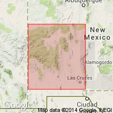
- Orogrande basin
Summary:
Sierra Ladrones Formation of Santa Fe Group. Consists of: (1) piedmont slope and alluvial fan deposits, light-brown to light-reddish-brown sandstone and fanglomerate, 165+ m; (2) axial stream deposits, light-gray to light-yellowish-brown fine- to medium-grained sand and sandstone with fluvial cross-bedding and cut-and-fill channels, 205+ m; and (3) piedmont slope and alluvial flat deposits, light-brown to light-reddish-brown fine-grained sand and silt to coarse angular fanglomerate, interbedded with basalt near San Acacia (informal; K-Ar dated by H.H. Mehnert, written commun., 1976, at 4.5 +/-0.1 Ma), 100+ m. Total thickness 470+ m; base not exposed and top eroded. Is = upper buff member and part of middle red member of Santa Fe Formation of Bryan and McCann (1937). Unconformably overlies or in fault contact with Popotosa and older formations. Age is early Pliocene to middle Pleistocene; Pliocene-Pleistocene boundary placed at about 2 Ma, and Miocene-Pliocene boundary placed at about 5 Ma.
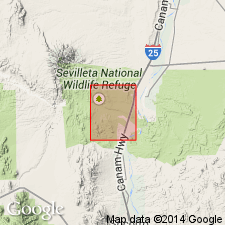
Type area in Sevilleta National Wildlife Refuge, San Acacia 7.5-min quadrangle, Socorro Co., central NM: (1) piedmont slope and alluvial fan deposits, west of Sierra Ladrones from Rio Salado to north bdry of Sevilleta Grant, (2) axial stream deposits, near Loma Blanca, and (3) piedmont slope and alluvial flat deposits, north and east of San Acacia dam, Socorro Co., NM. Named from Sierra Ladrones, low foothills of the Ladron Mountains, Sevilleta National Wildlife Refuge, San Acacia 7.5-min quadrangle, Socorro Co., central NM.
Source: Publication.
- Usage in publication:
-
- Sierra Ladrones Formation
- Modifications:
-
- Revised
- Geochronologic dating
- AAPG geologic province:
-
- Orogrande basin
Summary:
Is the upper formation of Santa Fe Group, Rio Grande valley, Socorro Co, NM, Orogrande basin. Is an axial-river sand of the ancestral Rio Grande. Includes related floodplain, piedmont, and alluvial-fan deposits. Ranges from 1-1,000 ft thick. The poorly indurated buff to red fanglomerate intertongues with gray, friable sandstone, red or green mudstone and siltstone, basalts of Socorro Canyon and of San Acacia. Basalt of Socorro Canyon has one or two dark-gray, fine-grained basalt flows, 0-100 ft thick, a K-Ar age of 4.1 +/-0.3 m.y.; its source is unknown. Basalt of San Acacia is a thin, local basaltic flow with a 4.6 +/-0.1 m.y. K-Ar date. Overlies Popotosa Formation of Santa Fe Group; underlies middle Pleistocene to Holocene deposits that postdate incision of ancestral Rio Grande. Of early Pliocene to middle Pleistocene.
Source: GNU records (USGS DDS-6; Denver GNULEX).
For more information, please contact Nancy Stamm, Geologic Names Committee Secretary.
Asterisk (*) indicates published by U.S. Geological Survey authors.
"No current usage" (†) implies that a name has been abandoned or has fallen into disuse. Former usage and, if known, replacement name given in parentheses ( ).
Slash (/) indicates name conflicts with nomenclatural guidelines (CSN, 1933; ACSN, 1961, 1970; NACSN, 1983, 2005, 2021). May be explained within brackets ([ ]).