

- Usage in publication:
-
- Shell Rock limestone
- Modifications:
-
- Revised
- AAPG geologic province:
-
- Iowa shelf
Summary:
Map, frontispiece. Restricted Shell Rock to beds below Nora limestone and above their Lower Cedar Valley, and divided into (descending) PACHYPHYLLUM zone, AULOPORA shale, Bloody Run zone, Lithographic beds, and Mud-crack zone.
[The Fenton and Webster (1924) citation in USGS Bull. 896 is a misprint.]
Source: US geologic names lexicon (USGS Bull. 896, p. 1978).
- Usage in publication:
-
- Shell Rock limestone
- Modifications:
-
- Named
- Dominant lithology:
-
- Limestone
- AAPG geologic province:
-
- Iowa shelf
Summary:
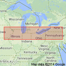
Pg. 411-412. In parts of Butler, Floyd, northeast Cerro Gordo, and counties to the north, there come in recognizable formations which are higher and faunally separable from the Cedar Valley. There are not thick, probably not exceeding 100 feet in vertical extent. The general group of these is called Shell Rock limestone, from their typical development along Shell Rock River between Rockford and Nora Springs and on northward, also about Mason City and to north and northwest. The upper member of this group is Nora limestone, whose sharp contact with basal blue shale of Lime Creek stage may be seen on Lime Creek just west of Rockford. Below the Nora at this point, and separated by a slight erosional unconformity, is a dolomitic limestone, the Mason City dolomite of Calvin. It is suggested that eventually the Shell Rock may be a stage with the Nora, Mason City, and possibly other horizons and substages.
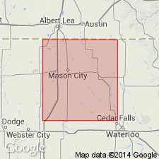
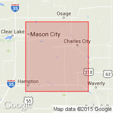
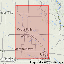
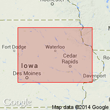
Typical development along Shell Rock River between Rockford and Nora Springs and on northward, also about Mason City and to north and northwest.
Source: US geologic names lexicon (USGS Bull. 896, p. 1978).
- Usage in publication:
-
- Shell Rock stage
- Modifications:
-
- Revised
- AAPG geologic province:
-
- Iowa shelf
Summary:
Included Nora limestone in his Shell Rock stage, but redefined Nora so as to include in it some beds (First ACTINOSTROMA zone) previously included in Mason City substage. He divided his Shell Rock stage into (descending): (1) Nora substage (including Second ACTINOSTROMA zone, PLATYRACHELLA zone, First ACTINOSTROMA zone); (2) Rock Grove substage (SCHIZOPHORIA zone and PARACYCLAS zone); (3) Mason City substage (LEPIDOCENTRUS zone, TRIGONOTRETA zone, and AULOPORA zone), and defined it as resting unconformably on Cedar Valley Limestone [restricted usage of name].
Source: US geologic names lexicon (USGS Bull. 896, p. 1978).
- Usage in publication:
-
- Shell Rock formation
- Modifications:
-
- Revised
- AAPG geologic province:
-
- Iowa shelf
Summary:
Pg. 344. In north-central Iowa the Shell Rock formation unconformably overlies Cedar Valley limestone and in north part of north-central province it is unconformably overlain by Juniper Hill shale. In south part of north-central province it is undoubtedly directly overlain by Sheffield formation. Consists of hard gray fossiliferous limestone and dolomite.
Source: US geologic names lexicon (USGS Bull. 896, p. 1978).

- Usage in publication:
-
- Shell Rock limestone
- Modifications:
-
- Overview
- AAPG geologic province:
-
- Iowa shelf
Summary:
The Rept. 9th Ann. Field Conf. Kansas Geol. Soc., 1935, fig. 1, adopted Belanski's 1927 definitions of Shellrock [Shell Rock] formation and Cedar Valley limestone, in that they divided their Shellrock [Shell Rock] formation into Nora, Rock Grove, and Mason City members, and showed it as unconformably on Cedar Valley limestone restricted. On pg. 356, M.A. Stainbrook gives thickness of Shellrock [Shell Rock] formation as 16 to 65 feet.
Source: US geologic names lexicon (USGS Bull. 896, p. 1978).
- Usage in publication:
-
- Shell Rock formation
- Modifications:
-
- Biostratigraphic dating
- AAPG geologic province:
-
- Iowa shelf
McNair, A.H., 1942, Upper Devonian Bryozoa: Journal of Paleontology, v. 16, no. 3, p. 343-350.
Summary:
Pg. 349-350. Fossil collections made from Mason City dolomite member of Shell Rock (Shellrock) formation.
Source: US geologic names lexicon (USGS Bull. 1200, p. 3568).
- Usage in publication:
-
- Shell Rock formation
- Modifications:
-
- Overview
- AAPG geologic province:
-
- Iowa shelf
Summary:
Pg. 661. Formation includes (ascending) Mason City, Rock Grove, and Nora members.
Source: US geologic names lexicon (USGS Bull. 1200, p. 3568).
- Usage in publication:
-
- Shell Rock Formation
- Modifications:
-
- Revised
- AAPG geologic province:
-
- Iowa shelf
Summary:
Assigned as upper formation of Cedar Valley Group (rank raised) in northern IA on the Iowa shelf. Overlies Lithograph City Formation (named) of Cedar Valley Group. Of Late Devonian age.
Source: GNU records (USGS DDS-6; Denver GNULEX).
- Usage in publication:
-
- Shell Rock Formation
- Modifications:
-
- Contact revised
- Reference
- Overview
- AAPG geologic province:
-
- Iowa shelf
Summary:
Lower contact revised in that Shell Rock Formation, upper formation of Cedar Valley Group (revised), disconformably overlies Idlewild Member (named) of Lithograph City Formation (named) of Cedar Valley Group. Subsurface reference section designated as the FM-4 core, sec 31, T96N, R18W, Floyd Co, IA. Occurs in northern IA, Iowa shelf, where it can be divided into (ascending): Mason City, Rock Grove, and Nora Members. The eroded upper surface was buried by the Lime Creek Formation. Is characterized by fossiliferous carbonates with some shale in type. Has laminated, "birdseye"-bearing brecciated, and intraclastic facies. Where capped by younger rocks, ranges from 17 to 24 m thick. Nomenclature charts, cross section, graphic sections. Of Late Devonian, Frasnian age.
Source: GNU records (USGS DDS-6; Denver GNULEX).
For more information, please contact Nancy Stamm, Geologic Names Committee Secretary.
Asterisk (*) indicates published by U.S. Geological Survey authors.
"No current usage" (†) implies that a name has been abandoned or has fallen into disuse. Former usage and, if known, replacement name given in parentheses ( ).
Slash (/) indicates name conflicts with nomenclatural guidelines (CSN, 1933; ACSN, 1961, 1970; NACSN, 1983, 2005, 2021). May be explained within brackets ([ ]).