The National Geologic Map Database is migrating to a new infrastructure. We apologize for any service disruptions during this process.
|
|---|


- Usage in publication:
-
- Sewanee Peak Volcanics*
- Modifications:
-
- Named
- Geochronologic dating
- Dominant lithology:
-
- Breccia
- Tuff
- Volcanics
- AAPG geologic province:
-
- Eagle basin
Summary:
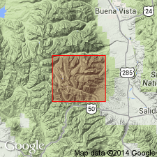
Named for exposures on Sewanee Peak, the type area, a summit on divide between Billings basin and heads of Chalk Creek and Middle Fork, South Arkansas River, Chaffee Co, CO in the Eagle basin. Mapped as quartz latite porphyry in earlier reports. Discontinuously exposed in area 4 x 6 km from Hancock Pass to Mount Aetna. Formerly more extensive. Reduced areal extent due to erosion and emplacement by younger intrusive units. Forms steep unstable slopes. Is hard, brittle, and broken by many closely spaced joints. Consists of a complex assemblage of volcanic and pyroclastic breccias, densely welded ash-flow tuffs, lava flows, and compacted air-fall deposits. Lithic fragments 1-5 cm diameter, mostly volcanic sporadically abundant in unit. Most of unit has a uniform megascopic appearance; is gray to green, very fine grained groundmass with abundant phenocrysts of feldspar 1-2 mm long, rarer biotite and hornblende. Rests on an irregular surface. Has a minimum thickness of 1 1/2 to 2 km. Separated from the older Mount Pomeroy Quartz Monzonite by a rubble zone of clasts, cobbles, boulders of Paleozoic sedimentary rocks, Mount Princeton Quartz Monzonite, Calico Mountain? Andesite, and from Sewanee Peak? itself. Rubble represents a weathered zone incorporated into the Sewanee Peak. Geologic maps. Ages of: 33.9 m.y. biotite, K-Ar; 3.5 m.y. and 33.6 +/-0.3 m.y. 39Ar/40Ar obtained. Oligocene age.
Source: GNU records (USGS DDS-6; Denver GNULEX).
For more information, please contact Nancy Stamm, Geologic Names Committee Secretary.
Asterisk (*) indicates published by U.S. Geological Survey authors.
"No current usage" (†) implies that a name has been abandoned or has fallen into disuse. Former usage and, if known, replacement name given in parentheses ( ).
Slash (/) indicates name conflicts with nomenclatural guidelines (CSN, 1933; ACSN, 1961, 1970; NACSN, 1983, 2005, 2021). May be explained within brackets ([ ]).