The National Geologic Map Database is migrating to a new infrastructure. We apologize for any service disruptions during this process.
|
|---|


- Usage in publication:
-
- Sentinel Gap flow
- Modifications:
-
- Original reference
- Dominant lithology:
-
- Basalt
- AAPG geologic province:
-
- Eastern Columbia basin
Summary:
Pg. 8, 13-14, 17, 21, 40. Sentinel Gap flow of Frenchman Springs Basalt Member of Yakima Basalt. Uppermost named flow in Frenchman Springs Basalt Member (new). Overlies Sand Hollow flow (new). Thickness 125 +/-10 feet at Sentinel Gap. Consists of solid basalt characterized by disorderly joint patterns, but containing irregularly distributed masses of pillow palagonite. Thins northward and pinches out completely within Vantage-Priest Rapids area. Overlain by Roza Basalt Member (new). Age is Miocene.
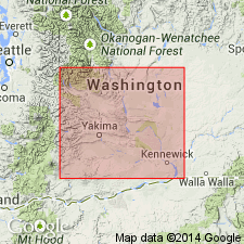
Named from Sentinel Gap, [along Columbia River] between Priest Rapids and Vantage, [in secs. 3, 4, 9, 10, 15, 16, T. 15 N., R. 23 E., Beverly 7.5-min quadrangle, Kittitas Co., Saddle Mountains], central southern WA.
Source: US geologic names lexicon (USGS Bull. 1350, p. 679).
For more information, please contact Nancy Stamm, Geologic Names Committee Secretary.
Asterisk (*) indicates published by U.S. Geological Survey authors.
"No current usage" (†) implies that a name has been abandoned or has fallen into disuse. Former usage and, if known, replacement name given in parentheses ( ).
Slash (/) indicates name conflicts with nomenclatural guidelines (CSN, 1933; ACSN, 1961, 1970; NACSN, 1983, 2005, 2021). May be explained within brackets ([ ]).