

- Usage in publication:
-
- Semilla Sandstone Member*
- Modifications:
-
- Named
- Dominant lithology:
-
- Sandstone
- AAPG geologic province:
-
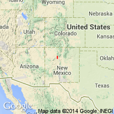
- San Juan basin
Summary:
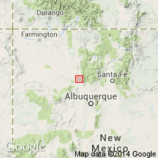
Named as a member of Mancos Shale, in its lower part for outcrops on west side, valley of Arroyo Semilla, northern San Ysidro 15 min quad, Sandoval Co, NM in San Juan basin. Type section measured from 2,000 to 3,000 ft north of Ojo del Espiritu Santo and about 1 mi east of NM State Hwy 44 on Ojo del Espiritu Santo Grant, Sandoval Co where a section 69 ft 9 in thick that overlies shale of Blue Hill or Carlile age and underlies shale of late Carlile age. Composed of very fine, fine- to medium-grained, well-sorted, yellowish-gray to yellowish-brown sandstone. Some beds silty; some are soft; some are fossiliferous (marine mollusks). Has several persistent zones of calcareous concretions. More than half the grains are quartz, 20 percent are microcline and orthoclase; 10 percent are plagioclase feldspar. Is free of ferromagnesian minerals. Has a north south extent of 35 mi and a width of 7 or 8 mi. Lies about 200 ft above top of Greenhorn Limestone Member of Mancos. Deposited in shallow marine water from evenly flowing offshore currents. Of Late Cretaceous age.
Source: GNU records (USGS DDS-6; Denver GNULEX).
- Usage in publication:
-
- Semilla Sandstone Member
- Modifications:
-
- Overview
- Areal extent
- AAPG geologic province:
-
- San Juan basin
Summary:
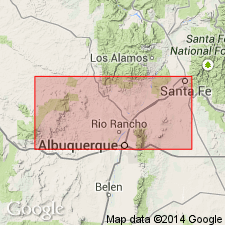
Crops out as a member of Upper Cretaceous Mancos Shale on eastern side of San Juan basin, NM, west of the Nacimiento Mountains. Not recognized on outcrop or in subsurface of western and northern parts of basin. Distribution map. Time-equivalent beds present in other parts of basin. The Blue Hill Shale and Codell Sandstone Members of CO and KS are equivalent to the Semilla. Is underlain by unnamed shale member of Mancos and overlain by Juana Lopez Member of Mancos. Deposited in several discrete offshore shallow-marine sandbars separated by muddy interbar areas. The bars--named Holy Ghost and Bernalillito Arroyo bars--are 10 to 15 km wide and 20 km long, and have a maximum thickness of 21 m. The bars elongated parallel to the shore were deposited 50 to 80 km offshore. Separable into 3 facies: 1) upper small-scale trough cross-bedded sandstone; 2) middle silty sandstone; and 3) basal transitional facies of gray, blocky, silty, fossiliferous (mollusks) shale. Upward coarsening of facies indicates shoaling. Cross section; columnar section. Petrographic description.
Source: GNU records (USGS DDS-6; Denver GNULEX).
- Usage in publication:
-
- Semilla Sandstone Member*
- Modifications:
-
- Biostratigraphic dating
- Age modified
- AAPG geologic province:
-
- San Juan basin
Summary:
Is member of Mancos Shale. Age refined as lower part is assigned a middle Turonian (Late Cretaceous) age based on presence of the ammonite SPATHITES PUERCOENSIS collected from USGS Mesozoic localities D4020, D4021, and D10575 in Sandoval Co, NM in the San Juan basin.
Source: GNU records (USGS DDS-6; Denver GNULEX).
- Usage in publication:
-
- Semilla Sandstone Member
- Modifications:
-
- Reference
- Areal extent
- AAPG geologic province:
-
- Estancia basin
- San Juan basin
Summary:
Exposures of this member of the Mancos Shale were identified south of Lamy (Galisteo lowlands) and south of Cerillos (Hagan basin), Santa Fe Co, NM in Estancia basin. These exposures are of upward transitional, sandy, bioturbated, interbedded and cross-bedded shelf facies sand ridge deposits. Contacts with overlying and underlying parts of Mancos Shale. Reference section designated in Hagan basin, sec 5, T12N, R7E where the sandstone: is about 12 m thick, can be traced for 1.7 mi; lies about 28 m below top of Juana Lopez Member of Mancos; contains the index fossil PRIONOCYCLUS HYATTI (Stanton); has a covered basal contact; consists of 1) thinly bedded, horizontally laminated, very fine grained, muddy sandstone and shale that grade upward to 2) poorly sorted, medium-grained bioturbated sandstone and some shale, and to 3) horizontally stratified, densely burrowed sandstone. Unit 2 has phosphate pebbles as large as 4 mm diameter, shark teeth, shale casts, shell debris, and is 25 percent burrowed with OPHIOMORPHA and THALASSINOIDES. Reference section designated in Galisteo lowlands, sec 7, T12N, R10E where sandstone: lies 33 m below top of Juana Lopez; contains PRIONOCYCLUS HYATTI (Stanton); lower contact gradational into Mancos; has same three units as in Hagan basin. Of latest middle Turonian age. Cross sections; isopach maps.
Source: GNU records (USGS DDS-6; Denver GNULEX).
For more information, please contact Nancy Stamm, Geologic Names Committee Secretary.
Asterisk (*) indicates published by U.S. Geological Survey authors.
"No current usage" (†) implies that a name has been abandoned or has fallen into disuse. Former usage and, if known, replacement name given in parentheses ( ).
Slash (/) indicates name conflicts with nomenclatural guidelines (CSN, 1933; ACSN, 1961, 1970; NACSN, 1983, 2005, 2021). May be explained within brackets ([ ]).