The National Geologic Map Database is migrating to a new infrastructure. We apologize for any service disruptions during this process.
|
|---|


- Usage in publication:
-
- Screwauger Breccia*
- Modifications:
-
- Named
- Dominant lithology:
-
- Breccia
- Chert
- Quartzite
- AAPG geologic province:
-
- Sierra Nevada province
Summary:
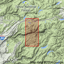
Screwauger Breccia is named for exposures on the southwest slope of Duncan Peak and in the adjacent upper reaches of Screwauger Canyon (sec.9,10,15,16, T15N R13E, Duncan Peak 7.5' quad), Placer Co, CA. Is a chaotic (type I melange) unit composed primarily of broken beds of quartzite in a black pelite matrix. Mappable blocks of gray ribbon chert, fine- to coarse-grained massive orthoquartzite, and quartz-feldspar granule conglomerate occur sporadically in the unit. Total thickness is unknown, but maximum exposed thickness is at least 300 m. Overlies the Antoine Canyon Formation (new) [locally?]; underlies the Big Valley Bluff Formation (new). Age is Ordovician(?) to Devonian(?) based on regional stratigraphic relationships.
Source: GNU records (USGS DDS-6; Menlo GNULEX).
For more information, please contact Nancy Stamm, Geologic Names Committee Secretary.
Asterisk (*) indicates published by U.S. Geological Survey authors.
"No current usage" (†) implies that a name has been abandoned or has fallen into disuse. Former usage and, if known, replacement name given in parentheses ( ).
Slash (/) indicates name conflicts with nomenclatural guidelines (CSN, 1933; ACSN, 1961, 1970; NACSN, 1983, 2005, 2021). May be explained within brackets ([ ]).