

- Usage in publication:
-
- Schrader Bluff formation*
- Modifications:
-
- Named
- Biostratigraphic dating
- Dominant lithology:
-
- Sandstone
- Shale
- AAPG geologic province:
-
- Alaska Northern region
Summary:
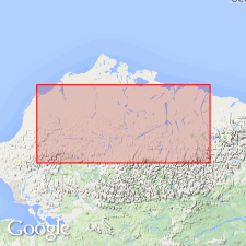
Named as formation in Colville group for exposures at Schrader Bluff on Anaktuvuk River about 5 mi above mouth of Tuluga River, northern AK, also designated as type locality. Rocks formerly called "Nanushuk series" by Schrader (1904). Comprises three members (ascending): Seabee, Tuluga, and Sentinel Hill (all new). Is largely marine sandstone to south and shale to north. Contains considerable bentonite and tuff which increases upward. Thickness at Fish Creek test well no.1 is 2600 ft. Overlies Umiat formation (new) of Nanushuk group in Umiat area and to south; also overlies Chandler formation (new) of Nanushuk group to south. Intertongues with nonmarine Prince Creek formation (new) of Colville Group. Underlies Sagavanirktok formation (new). Age is Late Cretaceous based on megafossils.
Source: GNU records (USGS DDS-6; Menlo GNULEX).
- Usage in publication:
-
- Schrader Bluff formation*
- Modifications:
-
- Revised
- AAPG geologic province:
-
- Alaska Northern region
Summary:
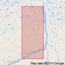
Type locality redefined by restricting it to steeply south-dipping marine rocks in Schrader Bluff from top of Tuluvak tongue (800 ft above base) to top of exposure (2700 ft above base). Divided into three members (ascending): Rogers Creek member (new), Barrow Trail member (new), and Sentinel Hill member. Seabee member of Gryc and others (1951) is redefined as Seabee formation. Tuluga Member of Gryc and others (1951) is abandoned; its rocks now included in Rogers Creek and Barrow Trail members and upper part of Seabee Formation. Thickness is about 2200 ft along Colville River northeast of Umiat and includes nonmarine tongue 335 ft thick. Is at least 1900 ft thick at Schrader Bluff. Mollusks, foraminifers, and radiolarians are found in members.
Source: GNU records (USGS DDS-6; Menlo GNULEX).
- Usage in publication:
-
- Schrader Bluff Formation*
- Modifications:
-
- Revised
- Age modified
- Reference
- AAPG geologic province:
-
- Alaska Northern region
Summary:
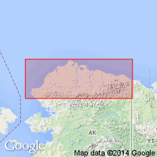
Pg. 3-5 (figs. 2-4), 6-8 (table 1), 26-29. Schrader Bluff Formation. Removed from †Colville Group (abandoned). Previously subdivided into (ascending) †Rogers Creek, †Barrow Trail, and †Sentinel Hill Members (all abandoned); poorly exposed, and lower and upper members generally undistinguishable. Where applicable, the Schrader Bluff is subdivided into unnamed lower, middle, and upper parts. Middle part consists of hummocky and swaley cross-bedded, 25 to 65 feet thick sandstones separated by intervals of siltstone, tuffaceous siltstone, tuff, and shale; contains trace fossil MACARONICHNUS. Lower and upper parts consists of varying amounts of bentonite interbedded with bentonitic shale, tuffaceous mudstone, and bentonitic, fine-grained, fossiliferous sandstone. Total thickness of formation about 1,800 to 2,500 feet. Underlies and interfingers with Prince Creek Formation (revised). Overlies Tuluvak Formation (revised) to southwest, notably in Chandler River region, and overlies and interfingers with Canning Formation to northeast, notably in Kavik River region. Fossils (bivalves, palynomorphs). Age is Late Cretaceous (Santonian to Maastrichtian); becomes younger from southwest to northeast.
Reference sections (middle part):
(1) Schrader Bluff type section, on Anaktuvuk River, about 5 mi above mouth of Tuluga River, east of Umiat, in sec. 30, T. 3 S., R. 5 E., [approx. Lat. 69 deg. 09 min. 24 sec. N., Long. 151 deg. 01 min. 24 sec. W., Umiat A-2 quadrangle, scale 1:63,360], northern AK; and
(2) Shivugak Bluff on north side of Colville River, 10 mi downstream from Umiat, in sec. 19, T. 1 N., R. 2 E., [approx. Lat. 69 deg. 25 min. 48 sec. N., Long. 151 deg. 42 min. 42 sec. W., Umiat B-3 quadrangle, scale 1:63,360], northern AK.
Typical exposures (middle part): Outpost Mountain, in T. 3 S., R. 4 E., [Umiat A-3 quadrangle, scale 1:63,360], northern AK; and Tattitgak Bluff, on Colville River 3 mi southwest of Umiat, in sec. 25, T. 1 S., R. 2 W., [Umiat B-4 quadrangle, scale 1:63,360], northern AK.
Source: Publication.
For more information, please contact Nancy Stamm, Geologic Names Committee Secretary.
Asterisk (*) indicates published by U.S. Geological Survey authors.
"No current usage" (†) implies that a name has been abandoned or has fallen into disuse. Former usage and, if known, replacement name given in parentheses ( ).
Slash (/) indicates name conflicts with nomenclatural guidelines (CSN, 1933; ACSN, 1961, 1970; NACSN, 1983, 2005, 2021). May be explained within brackets ([ ]).