

- Usage in publication:
-
- Scheggs Bed*
- Modifications:
-
- Named
- Dominant lithology:
-
- Oil-shale
- Dolomite
- Limestone
- Sandstone
- Siltstone
- Tuff
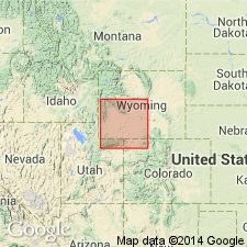
- AAPG geologic province:
-
- Green River basin
Summary:
Named basal bed Tipton Shale Member (or Tipton Tongue where Cathedral Bluffs Tongue of Wasatch Formation overlies Tipton) of Green River Formation for exposures east slope of Scheggs Draw. Present in most of Greater Green River basin, southwest WY, northwest CO. Type section measured N1/2 sec 36, T15N, R101W; S1/2 sec 25, T15N, R100 1/2 W, Sweetwater Co, WY. Intertongues laterally with Farson Sandstone Member (new) of Green River and with Battle Spring Formation. Basal contact with Niland Tongue (Wasatch) intertonguing. Upper contact with Rife Bed (new) of Tipton sharp, marked by color change from brown-weathering oil shale (Scheggs) to light-gray-weathering oil shale (Rife), and change from soft, tan to brown oil shale, few algal limestones (Scheggs) to dark-brown to black dolomite, oil shale, algal limestones (Rife). Conformable over Rife across south and east parts of Greater Green River basin; never in contact central part of basin and along northwest flank Rock Springs uplift. Separated from Rife by Farson on northwest flank of uplift. Thickness: 59.1 ft at type; range 10-200+ ft. Consists of brown oil shale and one tan dolomite bed at type. May contain thin limestone, dolomite, sandstone, siltstone, carbonaceous shale, coal, tuff, local conglomerate lenses. Freshwater gastropods in basal beds; ostracods abundant. Freshwater lacustrine deposit of late early Eocene age. Cross section, areal extent map, columnar section.
Source: GNU records (USGS DDS-6; Denver GNULEX).
- Usage in publication:
-
- Scheggs Bed*
- Modifications:
-
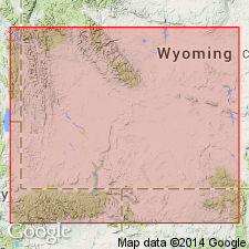
- Areal extent
- Overview
- AAPG geologic province:
-
- Green River basin
Summary:
Isopach map (fig 19) shows areal extent within Greater Green River basin, WY and CO. Lake in which Scheggs (Tipton Shale Member of Green River Formation) was deposited was 180 mi long by 100 mi wide. Scheggs is 300 ft thick in southwest part of Washakie and in western part of Sand Wash basins; 200 ft thick in Uinta Mountain trough north of Uinta Mountains; and 50 ft thick in Great Divide basin, northern Rock Springs uplift, and central and northern Green River basin. Stratigraphic chart; cross sections. Eocene age.
Source: GNU records (USGS DDS-6; Denver GNULEX).

- Usage in publication:
-
- Scheggs Bed*
- Modifications:
-
- Overview
- AAPG geologic province:
-
- Green River basin
Summary:
Paleogeographic map (fig. 50) of this bed of Tipton Shale Member of Green River Formation showing depositional environments in Greater Green River basin. Scheggs deposited during first major expansion of Lake Gosiute from Uinta Mountain trough. Lake reached a maximum areal extent of 15,000 sq mi occupying about 75% of basin. Sediments deposited in lake during Scheggs time were mostly organic muds (oil shale) with sand around lake's margins; calcareous algal reefs (stromatolites) were abundant in shallow waters of lake and several sand deltas were present along lake's eastern shore. Deepest part of lake (300 ft) was located in southern part of basin along trend of Uinta Mountain trough. Backshore areas of lake consisted of flood plains; arkosic sediments of Battle Spring Formation were deposited in northeastern part of basin. Near end of deposition of Scheggs, Wind River Mountains were uplifted and subsequent erosion resulted in deposition of Farson Sandstone Member of Green River. Overlies Niland Tongue of Wasatch Formation; underlies and intertongues with Farson and underlies Rife Bed of Tipton. Generalized stratigraphic correlation chart (fig. 41). Geologic map (fig. 1) of Vermilion Creek area, northwest CO. Eocene age.
Source: GNU records (USGS DDS-6; Denver GNULEX).
For more information, please contact Nancy Stamm, Geologic Names Committee Secretary.
Asterisk (*) indicates published by U.S. Geological Survey authors.
"No current usage" (†) implies that a name has been abandoned or has fallen into disuse. Former usage and, if known, replacement name given in parentheses ( ).
Slash (/) indicates name conflicts with nomenclatural guidelines (CSN, 1933; ACSN, 1961, 1970; NACSN, 1983, 2005, 2021). May be explained within brackets ([ ]).