

- Usage in publication:
-
- Saunders formation*
- Modifications:
-
- Revised
- Areal extent
- AAPG geologic province:
-
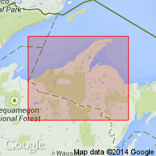
- Lake Superior region
Summary:
Revised--part of Chocolay group (new) of Animikie series, northwestern MI in the Lake Superior region. Not present in parts of Iron and Dickinson Cos, but considered partly correlative with both Randville dolomite and Sturgeon quartzite in this area. Stratigraphic sequence chart. Is middle Precambrian in age.
Source: GNU records (USGS DDS-6; Reston GNULEX).
- Usage in publication:
-
- Saunders Formation*
- Modifications:
-
- Overview
- AAPG geologic province:
-
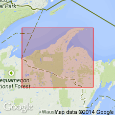
- Lake Superior region
Summary:
Pg. 2845 (fig. 2, stratigraphic chart compiled from Leith and others, 1935; James, 1958; Gair and Thaden, 1968). Saunders Formation of Chocolay Group of Marquette Range Supergroup (new; replaces †Animikie series of James, 1958, south of Lake Superior, in Michigan and Wisconsin). Present in Iron River-Crystal Falls district, northwestern Michigan. An unconformity separates the Saunders from underlying lower Precambrian greenstone, whose stratigraphic position is uncertain. Age is middle Precambrian.
Source: Publication.
For more information, please contact Nancy Stamm, Geologic Names Committee Secretary.
Asterisk (*) indicates published by U.S. Geological Survey authors.
"No current usage" (†) implies that a name has been abandoned or has fallen into disuse. Former usage and, if known, replacement name given in parentheses ( ).
Slash (/) indicates name conflicts with nomenclatural guidelines (CSN, 1933; ACSN, 1961, 1970; NACSN, 1983, 2005, 2021). May be explained within brackets ([ ]).