

- Usage in publication:
-
- Sauk sequence
- Modifications:
-
- Named
- AAPG geologic province:
-
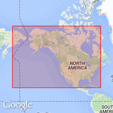
- Wisconsin arch
- North America
Summary:
Is name proposed for lowest (of four) Paleozoic sequence, after Sauk Co, in driftless area of southern WI, on Wisconsin arch. Sequences ("operational units" established to facilitate interregional facies mapping) are assemblages of strata separated by objective horizons; should be considered as rock units, assemblages of formations and groups. Within Sauk Co all rocks of the sequence are exposed with both bounding horizons, one at base of Dresbach sandstone, where they lie unconformably on pre-Cambrian Baraboo quartzite, the other at the contact between the St. Peter sandstone and the Oneota dolomite. Table 2 shows formations involved in limits of Sauk at various localities on mid-America craton; fig. 6 is isopach and lithofacies map; fig. 7 is tectofacies map. Gradation of Sauk rocks noted from predominant sandstone in WI to predominant carbonates in MO. Age of strata in the sequence in most cases is Late Proterozoic to Late Cambrian.
Source: GNU records (USGS DDS-6; Denver GNULEX).
- Usage in publication:
-
- Sauk sequence*
- Modifications:
-
- Overview
- AAPG geologic province:
-
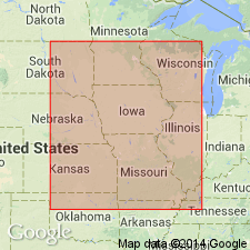
- Many basins
Summary:
Isopach and lithofacies map of the Upper Cambrian and Lower Ordovician part of the Sauk sequence in the northern Midcontinent area (bounded by latitudes 36 deg-46 deg N and longitudes 88 deg-100 deg W). Shows pinchout of Sauk sequence across eastern KS, NE, IA, MN, and WI, and thickening of Sauk rocks south and east from pinchout. Along west side of study area, the sequence thickens to 800 ft in southern KS and rapidly to greater than 2,800 ft in northern OK on north flank of Anadarko basin. In eastern part of study area, the sequence thickens gradually southeastward to about 2,000 ft across southern IL, southeast MO, and northern AR, and then rapidly thickens into the Mississippi embayment, exceeding 9,000 ft thick in Illinois basin. Carbonate rocks comprise at least two-thirds of the sequence in most of the area; 80 percent or more of the carbonates are dolomite. The part of the sequence treated in this report includes the Upper Cambrian Bonneterre and correlative formations at the base, and the top of the sequence is drawn at the base of the Middle Ordovician St. Peter Sandstone. Figure 1 shows generalized correlation chart for Sauk II and Sauk III rocks in the Midcontinent region of KS, IA, MO, and IL.
Source: GNU records (USGS DDS-6; Denver GNULEX).
- Usage in publication:
-
- Sauk sequence
- Modifications:
-
- Biostratigraphic dating
- AAPG geologic province:
-
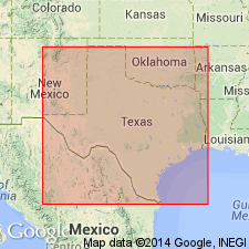
- Orogrande basin
Summary:
Biostratigraphic dating based on conodonts collected from upper part of Bliss Sandstone in type area, El Paso, TX at south end of Franklin Mountains in Orogrande basin. Bliss is noted as the basal clastic unit of the Sauk sequence in southern NM and westernmost TX. Conodonts assignable to ROSSODUS MANITOUENSIS zone of Early Ordovician (early Canadian) age.
Source: GNU records (USGS DDS-6; Denver GNULEX).
For more information, please contact Nancy Stamm, Geologic Names Committee Secretary.
Asterisk (*) indicates published by U.S. Geological Survey authors.
"No current usage" (†) implies that a name has been abandoned or has fallen into disuse. Former usage and, if known, replacement name given in parentheses ( ).
Slash (/) indicates name conflicts with nomenclatural guidelines (CSN, 1933; ACSN, 1961, 1970; NACSN, 1983, 2005, 2021). May be explained within brackets ([ ]).