

- Usage in publication:
-
- Saugahatchee quartzite member
- Modifications:
-
- Named
- Dominant lithology:
-
- Chert
- AAPG geologic province:
-
- Piedmont-Blue Ridge province
Summary:
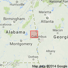
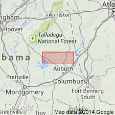
Saugahatchee quartzite member divides the Loachapoka nearly in half. Unit is exposed intermittently for 110 km from Notasulga, AL, to Harris, GA. Invaded by Farmville granite. Consists of metamorphosed impure chert interbedded with lutites, thin tuffs or volcaniclastic sediments up to 40 m thick. General age of Paleozoic given.
Source: GNU records (USGS DDS-6; Reston GNULEX).
- Usage in publication:
-
- Saugahatchee quartzite
- Modifications:
-
- Overview
- AAPG geologic province:
-
- Piedmont-Blue Ridge province
Summary:
Quartzite units in Loachapoka Schist of Opelika complex are informally referred to here as Saugahatchee quartzite. Authors mention that spelling used by Sears and others (1981) and applied here is inconsistent with spelling of creek name, which is Sougahatchee.
Source: GNU records (USGS DDS-6; Reston GNULEX).
- Usage in publication:
-
- Saugahatchee quartzite
- Modifications:
-
- Not used
- AAPG geologic province:
-
- Piedmont-Blue Ridge province
Summary:
Lithologic units that compose the Jacksons Gap Group do not disappear beneath the Coastal Plain as previously thought, but can be mapped eastward around the hinge zone of the Tallassee synform where along the eastern limb they become the Loachapoka Schist of the Opelika Complex. The Loachapoka continues along the east limb of the synform into GA where it corresponds to the Sandy Springs thrust sheet of Higgins and others (1988). The Saugahatchee quartzite of the Loachapoka Schist, the Tallassee and Devils Backbone quartzites of the Jacksons Gap Group, and the Chattahoochee Palisades Quartzite are correlative. Authors suggest that the name Chattahoochee Palisades Quartzite be applied to these quartzites and further recommend that the schists of the Loachapoka and Jacksons Gap Group be referred to as the Factory Shoals Formation of the Sandy Springs Group.
Source: GNU records (USGS DDS-6; Reston GNULEX).
For more information, please contact Nancy Stamm, Geologic Names Committee Secretary.
Asterisk (*) indicates published by U.S. Geological Survey authors.
"No current usage" (†) implies that a name has been abandoned or has fallen into disuse. Former usage and, if known, replacement name given in parentheses ( ).
Slash (/) indicates name conflicts with nomenclatural guidelines (CSN, 1933; ACSN, 1961, 1970; NACSN, 1983, 2005, 2021). May be explained within brackets ([ ]).