The National Geologic Map Database is migrating to a new infrastructure. We apologize for any service disruptions during this process.
|
|---|


- Usage in publication:
-
- Santa Rita granodiorite porphyry
- Modifications:
-
- Original reference
- Dominant lithology:
-
- Porphyry
- AAPG geologic province:
-
- Basin-and-Range province
Summary:
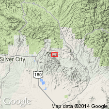
Pg. 288-289, 302, fig. 3, pl. 1. Santa Rita granodiorite porphyry. A single intrusive mass of biotite granodiorite porphyry. Groundmass of equigranular, interlocking grains of quartz and slightly sericitized orthoclase. Lustrous, striated green-gray feldspar phenocrysts common; occasional phenocrysts of hornblende and quartz. Age is Late Cretaceous or younger.
Bounded body about 1 mi across best exposed in copper pits of Santa Rita copper mine, in southeastern corner of Santa Rita quadrangle, about 12 mi east of Silver City, Grant Co., southwestern NM.
Source: US geologic names lexicon (USGS Bull. 1200, p. 3468).
For more information, please contact Nancy Stamm, Geologic Names Committee Secretary.
Asterisk (*) indicates published by U.S. Geological Survey authors.
"No current usage" (†) implies that a name has been abandoned or has fallen into disuse. Former usage and, if known, replacement name given in parentheses ( ).
Slash (/) indicates name conflicts with nomenclatural guidelines (CSN, 1933; ACSN, 1961, 1970; NACSN, 1983, 2005, 2021). May be explained within brackets ([ ]).