

- Usage in publication:
-
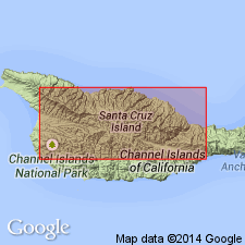
- Santa Cruz Island Volcanics
- Modifications:
-
- Named
- Geochronologic dating
- Dominant lithology:
-
- Volcaniclastics
- Andesite
- Basalt
- Dacite
- AAPG geologic province:
-
- Santa Maria basin
Summary:
Named for exposures [type locality] on north side of Santa Cruz Island fault, on Santa Cruz Island off southern coast of CA. Composed of primarily andesitic flows and volcaniclastics, with some basalt and dacite flows. Divided "informally" into four members (ascending): Griffith Canyon, Stanton Ranch, Devils Peak, and Prisoners Harbor Members (all new). Thickness ranges 5500 to 8000 ft. Underlies Monterey Formation. Overlies San Onofre Breccia and possibly Vaqueros Sandstone. Uppermost Prisoners Harbor Member has been radiometrically dated at 16.1 +/-0.8 Ma. Text states that no precise age is available for oldest rocks, or time span of volcanic rocks, "but entire pile was presumably emplaced within Saucesian Stage of upper Oligocene and lower Miocene", p.94. Age on map shown as Miocene.
Source: GNU records (USGS DDS-6; Menlo GNULEX).
- Usage in publication:
-
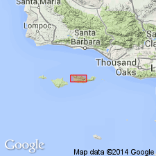
- Santa Cruz Island Volcanics*
- Modifications:
-
- Adopted
- Geochronologic dating
- Biostratigraphic dating
- AAPG geologic province:
-
- Santa Maria basin
Summary:
Santa Cruz Island Volcanics and its four members (ascending): Griffith Canyon, Stanton Ranch, Devils Peak, and Prisoners Harbor are adopted. K-Ar ages of 16.1 +/-0.8 and 15.7 +/-0.9 Ma are given for upper part of Prisoners Harbor Member (Turner, 1970). A foraminiferal assemblage collected from siltstone probably interbedded in Prisoners Harbor Member indicates a Relizian age (R.E. Arnal, written commun., 1975). A dike cutting lower part of Devils Peak Member was dated at 19.4 +/-0.9 Ma (plagioclase) and 15.5 +/-0.7 Ma (whole rock). No ages have been determined from basal volcanic rocks; however rocks drilled in subsurface on east end of island indicate volcanic rocks are underlain by probable Saucesian-age San Onofre Breccia (Weaver and Meyers, 1969). Shown on generalized geologic sketch map of north-central Santa Cruz Island as of Tertiary age.
Source: GNU records (USGS DDS-6; Menlo GNULEX).
For more information, please contact Nancy Stamm, Geologic Names Committee Secretary.
Asterisk (*) indicates published by U.S. Geological Survey authors.
"No current usage" (†) implies that a name has been abandoned or has fallen into disuse. Former usage and, if known, replacement name given in parentheses ( ).
Slash (/) indicates name conflicts with nomenclatural guidelines (CSN, 1933; ACSN, 1961, 1970; NACSN, 1983, 2005, 2021). May be explained within brackets ([ ]).