


- Usage in publication:
-
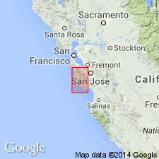
- Santa Clara lake beds
- Modifications:
-
- Original reference
- Dominant lithology:
-
- Gravel
- Alluvium
- AAPG geologic province:
-
- Northern Coast Range province
Summary:
Pg. 171. Santa Clara lake beds. Fossil fresh-water shells have been found at several points on both sides of this valley, and at different heights above it, but sufficient specimens have not yet been collected to determine the ages, elevations, disturbances, etc., of the various beds. The oldest known is that at San Jose Mission, where a ridge apparently of Pliocene date remains as a remnant of a thick bed of gravel and alluvium once filling greater part of valley to depth of probably 300 feet above tides. The same deposit is seen at intervals from East Oakland along the foothills southward on east side of valley, and less abundantly on west side to near Redwood City, but does not everywhere contain fossils. It is considerably disturbed in some places, usually by elevation of the mountains since its deposit. Fossils from San Jose Mission listed. [Age is Pliocene and Pleistocene.]
[Appears to have been named for its considerable development in Santa Clara Co., western CA.]
Source: US geologic names lexicon (USGS Bull. 896, p. 1922).
- Usage in publication:
-
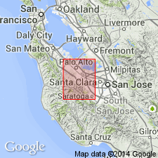
- Santa Clara formation*
- Modifications:
-
- Redescribed
- Age modified
- Dominant lithology:
-
- Gravel
- Sand
- Clay
- AAPG geologic province:
-
- California Coast Ranges province
Summary:
Santa Clara formation. Coarse gravel, sand, and sandy clay, locally lignitic, containing a fresh-water fauna [listed]. Thickness at least 500 feet. Greater part is contemporaneous with Paso Robles formation. Rests, probably conformably, on Purisima formation. Overlain by Quaternary deposits. Recent alluvium rests unconformably on it in at least one place. Considered contemporaneous with Merced formation. [Age is Pliocene and Pleistocene.]
[Santa Clara lake beds redescribed as Santa Clara formation] In Santa Cruz 30' quad extends from Crystal Springs Lake southeastward through Portola Valley hence up Corte de Madera Creek and over divide into Stevens Creek Canyon. Also occurs northwest of Saratoga. Fresh-water beds are largely gravels, soft marly sands, and clays with some thin beds of lignite. Is probably at least 500 ft thick. Probably unconformably overlies Purisima formation. Underlies Quaternary deposits. Age is probably late Pliocene and early Quaternary based on fresh-water fauna which are listed.
Source: GNU records (USGS DDS-6; Menlo GNULEX).
- Usage in publication:
-
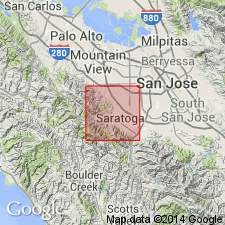
- Santa Clara Formation*
- Modifications:
-
- Overview
- AAPG geologic province:
-
- California Coast Ranges province
Summary:
Type area designated as exposures between Saratoga and Stevens Creeks. Type section is in Stevens Creek, 0.25 mi west of southeastern corner, sec.28 T7N R2W north along west side of Stevens Creek reservoir to axis of syncline 0.25 mi north of southwestern corner, sec.22 T7N R2W. Northeast of San Andreas fault Santa Clara Formation including its lake beds unconformably(?) overlies Merced(?) Formation. Southwest of San Andreas fault unit unconformably(?) overlies Purisima Formation. Age is presumably early Pleistocene because of regional unconformity at its base and probably unconformable relationship to Merced(?) Formation.
Source: GNU records (USGS DDS-6; Menlo GNULEX).
- Usage in publication:
-
- Santa Clara Formation*
- Modifications:
-
- Overview
- AAPG geologic province:
-
- California Coast Ranges province
Summary:
Sketch map shows distribution of Santa Clara Formation and eight lithofacies: Crystal Springs I and II, Woodside, Searsville, Arastradero, Stevens Creek, Los Gatos, and Corte Madera facies. Lithologic descriptions, clast composition table, pebble composition table, sources of Corte Madera facies included in report. No age-diagnostic fossils have been found. Hence age assigned is based on stratigraphic and structural relationships. Lower part is no older than latest Pliocene and may be no older than early Pleistocene. Uppermost beds are probably no younger than middle or early late Pleistocene.
Source: GNU records (USGS DDS-6; Menlo GNULEX).
- Usage in publication:
-
- Santa Clara Formation*
- Modifications:
-
- Age modified
- AAPG geologic province:
-
- California Coast Ranges province
Summary:
Age of Santa Clara Formation given as late Pliocene and early Pleistocene in map legend.
Source: GNU records (USGS DDS-6; Menlo GNULEX).
For more information, please contact Nancy Stamm, Geologic Names Committee Secretary.
Asterisk (*) indicates published by U.S. Geological Survey authors.
"No current usage" (†) implies that a name has been abandoned or has fallen into disuse. Former usage and, if known, replacement name given in parentheses ( ).
Slash (/) indicates name conflicts with nomenclatural guidelines (CSN, 1933; ACSN, 1961, 1970; NACSN, 1983, 2005, 2021). May be explained within brackets ([ ]).