The National Geologic Map Database is migrating to a new infrastructure. We apologize for any service disruptions during this process.
|
|---|


- Usage in publication:
-
- Sanpete formation*
- Modifications:
-
- Named
- Dominant lithology:
-
- Sandstone
- Shale
- Conglomerate
- AAPG geologic province:
-
- Wasatch uplift
Summary:
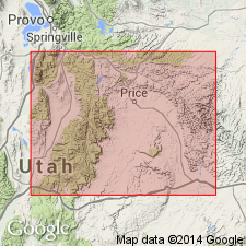
Named as the basal formation (of four formations) of the Indianola group (new) for exposures on the east side of the Sanpete Valley, south of Manti, Sanpete Co, UT, Wasatch uplift. No type locality designated. Exposed as hogbacks on low ridges. Recognized also in Salina Canyon where it is 1,350 ft thick. Consists of brown, ochre, buff, and gray sandstone, gray to ochre shale, mainly sandy, and gray conglomerate. Conglomerate present in lower part. Fossils found in upper part are of early Colorado age. Is equivalent to basal Mancos shale and possibly Dakota? sandstone of the Castle Valley area. Represents a nearshore deposit, between the open sea to the east and the mountain front to the west. Overlies Morrison? formation. Underlies the newly named Allen Valley shale of the Indianola. Of Late Cretaceous age. Stratigraphic table.
Source: GNU records (USGS DDS-6; Denver GNULEX).

- Usage in publication:
-
- Sanpete Formation*
- Modifications:
-
- Age modified
- AAPG geologic province:
-
- Wasatch uplift
Summary:
Is of late Cenomanian and early Turonian age. Palynomorphs identified in NW1/4 SW1/4 sec 7, T19S, R2E, Sanpete Co, UT on the Wasatch uplift.
Source: GNU records (USGS DDS-6; Denver GNULEX).
- Usage in publication:
-
- Sanpete Formation
- Modifications:
-
- Revised
- AAPG geologic province:
-
- Wasatch uplift
Summary:
Revised in that new unnamed basal unit assigned to Indianola Group (revised). Basal unit occurs along west side of Gunnison Reservoir and extends southwestward for about 5 mi to U. S. Highway 89, Sanpete Co, UT, Wasatch uplift. Described in condensed stratigraphic sections (tables 1 and 2) at, and south of, Radio Tower Valley. Underlies Allen Valley Formation of Indianola. Stratigraphic column. Assigned Late Cretaceous (Turonian) age.
Source: GNU records (USGS DDS-6; Denver GNULEX).
For more information, please contact Nancy Stamm, Geologic Names Committee Secretary.
Asterisk (*) indicates published by U.S. Geological Survey authors.
"No current usage" (†) implies that a name has been abandoned or has fallen into disuse. Former usage and, if known, replacement name given in parentheses ( ).
Slash (/) indicates name conflicts with nomenclatural guidelines (CSN, 1933; ACSN, 1961, 1970; NACSN, 1983, 2005, 2021). May be explained within brackets ([ ]).