

- Usage in publication:
-
- Sanderson formation
- Modifications:
-
- Named
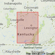
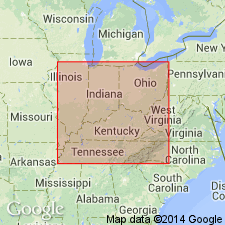
- Areal extent
- Dominant lithology:
-
- Shale
- AAPG geologic province:
-
- Cincinnati arch
Summary:
Name proposed for division of the New Albany between the Blackiston and Underwood or Henryville formations (all new). Thickness 10 ft. Contains two fossiliferous beds, each with layers of phosphatic nodules at top. Shale is less hard, less brittle, and less black than the upper Blackiston shale, but is so similar that under varying conditions of weathering, the two cannot be distinguished on lithology. Includes Falling Run member (new) at top. Uniform in character from IN into KY and from Lake Erie to TN. Southwest of Irvine, KY, the Falling Run member is present and is overlain by the New Providence. From Irvine north through OH, the Falling Run is absent and the Sanderson is overlain by Bedford shale. Age is Early Mississippian.
Source: GNU records (USGS DDS-6; Reston GNULEX).
- Usage in publication:
-
- Sanderson member
- Modifications:
-
- Revised
- AAPG geologic province:
-
- Cincinnati arch
Summary:
Mississippian part of New Albany has been divided into (ascending) Sanderson, Underwood, and Henryville "formations." Indiana Geological Survey uses these terms with rank of member.
Source: GNU records (USGS DDS-6; Reston GNULEX).
- Usage in publication:
-
- Sanderson Formation
- Modifications:
-
- Age modified
- AAPG geologic province:
-
- Cincinnati arch
Summary:
Age of Sanderson Formation of New Albany Group listed as Late Devonian in this report.
Source: GNU records (USGS DDS-6; Reston GNULEX).
- Usage in publication:
-
- Sanderson Formation
- Modifications:
-
- Not used
- AAPG geologic province:
-
- Cincinnati arch
Summary:
Sanderson Formation of Campbell (1946) not used in this report. Unit is replaced by the Clegg Creek Member of the New Albany Shale.
Source: GNU records (USGS DDS-6; Reston GNULEX).
- Usage in publication:
-
- Sanderson Member
- Modifications:
-
- Revised
- AAPG geologic province:
-
- Cincinnati arch
Summary:
Huron Shale of New Albany Group in southern IN and northwestern KY includes Sanderson (top), Clegg Creek, Camp Run, and Morgan Trail Members. Revision of Albany-Ohio-Chattanooga Shales based primarily on paracontinuities and associated bone beds. Includes PROTOSALVINIA biozone at base, which is also present in upper Gassaway Member of Chattanooga Shale in TN and Ohio Shale in OH. Age is Late Devonian.
Source: GNU records (USGS DDS-6; Reston GNULEX).
For more information, please contact Nancy Stamm, Geologic Names Committee Secretary.
Asterisk (*) indicates published by U.S. Geological Survey authors.
"No current usage" (†) implies that a name has been abandoned or has fallen into disuse. Former usage and, if known, replacement name given in parentheses ( ).
Slash (/) indicates name conflicts with nomenclatural guidelines (CSN, 1933; ACSN, 1961, 1970; NACSN, 1983, 2005, 2021). May be explained within brackets ([ ]).