

- Usage in publication:
-
- Sanctuary Formation*
- Modifications:
-
- Named
- Biostratigraphic dating
- Dominant lithology:
-
- Shale
- AAPG geologic province:
-
- Alaska East-Central region
- Alaska Southern region
Summary:
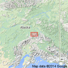
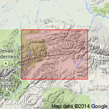
Named for exposures on east bank of Sanctuary River, about 1 mi south of north boundary of Mount McKinley National Park. Type section designated as outcrops east of Suntrana tipple, SW/4 sec.24 T12S R7W, Healy D-4 quad, east-central AK. Consists of finely banded brown-weathering shale, 90 to 130 ft thick at type locality. Is as much as 350 ft thick at east end of Healy Creek coal basin. Conformably overlies Healy Creek Formation (new) or older rocks; conformably underlies Suntrana Formation (new). Assigned to early or middle Miocene age or both on basis of fossil flora (Wolfe and Tanai, 1980).
Source: GNU records (USGS DDS-6; Menlo GNULEX).
- Usage in publication:
-
- Sanctuary Formation*
- Modifications:
-
- Revised
- Age modified
- AAPG geologic province:
-
- Alaska East-Central region
- Alaska Southern region
Summary:
Sanctuary Formation is assigned as next to oldest formation (of 5) to Usibelli Group (new). Age is modified from early and (or) middle Miocene to: middle Miocene on basis of [reinterpretation for] plant fossils.
Source: GNU records (USGS DDS-6; Menlo GNULEX).
For more information, please contact Nancy Stamm, Geologic Names Committee Secretary.
Asterisk (*) indicates published by U.S. Geological Survey authors.
"No current usage" (†) implies that a name has been abandoned or has fallen into disuse. Former usage and, if known, replacement name given in parentheses ( ).
Slash (/) indicates name conflicts with nomenclatural guidelines (CSN, 1933; ACSN, 1961, 1970; NACSN, 1983, 2005, 2021). May be explained within brackets ([ ]).