The National Geologic Map Database is migrating to a new infrastructure. We apologize for any service disruptions during this process.
|
|---|


- Usage in publication:
-
- San Miguel beds
- Modifications:
-
- Original reference
- Dominant lithology:
-
- Sandstone
- Clay
- AAPG geologic province:
-
- Gulf Coast basin
Summary:
Pg. 224-230. San Miguel beds. Thin- to heavy-bedded sandstones separated by bands of clay and containing seams of glauconitic material with many fossils and occasional heavy beds of clay, especially toward top. Thickness 800 feet. Included in Eagle Pass division. Underlies Coal series (Olmos formation) of Eagle Pass division and overlies Upson clays. Named for locality at which it was first observed by Dr. Comstock and myself; [the abandoned village of San Miguel, near Eagle Pass, Maverick County, southern Texas]. In Rio Grande section it first occurs in hills north of Carter's ranch, where the hills show exposures of it 75 to 100 feet in height. The exposures are excellent for several miles south of this point. [Fossils.] [Age is Late Cretaceous (Gulf).]
Source: US geologic names lexicon (USGS Bull. 896, p. 1916).
- Usage in publication:
-
- San Miguel beds
- Modifications:
-
- Areal extent
- AAPG geologic province:
-
- Gulf Coast basin
Summary:
Pg. 44. A good locality for observing San Miguel beds is near Arryoyo de las Navajas, on road from Piedras Negras to El Moral [Coahuila, Mexico].
Source: US geologic names lexicon (USGS Bull. 896, p. 1916).

- Usage in publication:
-
- San Miguel formation*
- Modifications:
-
- Overview
- AAPG geologic province:
-
- Gulf Coast basin
Summary:
L.W. Stephenson, 1931 (personal communication): The name San Miguel was proposed by Dumble and was derived from the abandoned village of San Miguel. In a letter to L.W. Stephenson dated Mar. 1, 1937, F.M. Getzendaner, of Uvalde, Texas, says: "Mr. Ed Smidt, who was born and reared at Eagle Pass, once told me that San Miguel was a ranch headquarters at the old rock house on Elm Creek, now within the boundaries of the J.K. Burr ranch, and about 13 miles north-northeast of Eagle Pass. I know definitely that the old rock house was built and occupied for many years by one San Miguel, a pioneer ranchman in Maverick County. * * * As you know, the old rock houae is within the outcrop ot the San Miguel formation."
Source: US geologic names lexicon (USGS Bull. 896, p. 1916).

- Usage in publication:
-
- San Miguel Formation
- Modifications:
-
- Mapped 1:250k
- Dominant lithology:
-
- Sandstone
- Limestone
- Clay
- AAPG geologic province:
-
- Gulf Coast basin
Summary:
San Miguel Formation. Consists of fossiliferous sand, sandy limestone, and unfossiliferous clay superficially like the underlying Upson, clay increases in amount upward; fossils include EXOGYRA PONDEROSA and numerous other marine megafossils. Thickness about 400 feet. Lies above Upson Clay and below Olmos Formation. Age is Late Cretaceous.
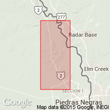
[Mapped in north-central and western Maverick Co., southwestern TX.]
Source: Publication.

- Usage in publication:
-
- San Miguel Formation
- Modifications:
-
- Mapped 1:250k
- Dominant lithology:
-
- Sandstone
- Limestone
- Clay
- AAPG geologic province:
-
- Gulf Coast basin
- Ouachita folded belt
Summary:
San Miguel Formation. Consists of fossiliferous sand, sandy limestone, and unfossiliferous clay superficially like the underlying Upson, clay increases in amount upward; fossils include EXOGYRA PONDEROSA and numerous other marine megafossils. Thickness up to about 800 feet, terminates abruptly eastward. Equivalent to Marlbrook Marl ("upper Taylor marl") in eastern part of San Antonio sheet. Age is Late Cretaceous.
Mapped in northern Maverick Co., and southeastern Kinney Co., southwestern TX.
Source: Publication.
For more information, please contact Nancy Stamm, Geologic Names Committee Secretary.
Asterisk (*) indicates published by U.S. Geological Survey authors.
"No current usage" (†) implies that a name has been abandoned or has fallen into disuse. Former usage and, if known, replacement name given in parentheses ( ).
Slash (/) indicates name conflicts with nomenclatural guidelines (CSN, 1933; ACSN, 1961, 1970; NACSN, 1983, 2005, 2021). May be explained within brackets ([ ]).