The National Geologic Map Database is migrating to a new infrastructure. We apologize for any service disruptions during this process.
|
|---|


- Usage in publication:
-
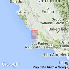
- San Luis formation
- Modifications:
-
- Original reference
- Dominant lithology:
-
- Sandstone
- Shale
- AAPG geologic province:
-
- Coastal basins
Summary:
San Luis formation. Usually earthy sandstone, but in places there is a great thickness of dark shale very similar to Toro formation. Contains many lentils of radiolarian jasper and some contact-metamorphic schist. Local representative of Franciscan. Represents all of Franciscan present in the area. Unconformably underlies Toro formation (Knoxville) and unconformably overlies serpentine and other basic igneous rocks. Age is Jurassic(?).
Named from development in San Luis Valley, San Luis Obispo Co., southern CA.
Source: US geologic names lexicon (USGS Bull. 896, p. 1915).

- Usage in publication:
-
- San Luis formation†
- Modifications:
-
- Abandoned
- AAPG geologic province:
-
- Coastal basins
Summary:
Replaced by Franciscan formation.
Source: US geologic names lexicon (USGS Bull. 896, p. 1915).
For more information, please contact Nancy Stamm, Geologic Names Committee Secretary.
Asterisk (*) indicates published by U.S. Geological Survey authors.
"No current usage" (†) implies that a name has been abandoned or has fallen into disuse. Former usage and, if known, replacement name given in parentheses ( ).
Slash (/) indicates name conflicts with nomenclatural guidelines (CSN, 1933; ACSN, 1961, 1970; NACSN, 1983, 2005, 2021). May be explained within brackets ([ ]).