The National Geologic Map Database is migrating to a new infrastructure. We apologize for any service disruptions during this process.
|
|---|


- Usage in publication:
-
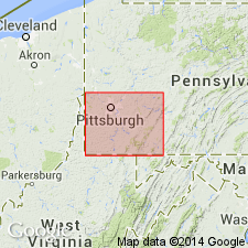
- Saltsburg sandstone
- Modifications:
-
- Named
- Dominant lithology:
-
- Sandstone
- AAPG geologic province:
-
- Appalachian basin
Summary:
Named for Saltsburg, Indiana Co., southwestern PA. Fine exposures are seen along Conemaugh and Loyalhanna Rivers near Saltsburg. Consists of sandstone. Thickness is 25 to 40 ft. Underlies Berlin(?) coal in Fayette and Westmoreland Cos.; overlies Platt(?) coal. Lies 165 ft above Mahoning sandstone and 100 ft below Morgantown sandstone. [Age is Pennsylvanian.]
Source: GNU records (USGS DDS-6; Reston GNULEX).
For more information, please contact Nancy Stamm, Geologic Names Committee Secretary.
Asterisk (*) indicates published by U.S. Geological Survey authors.
"No current usage" (†) implies that a name has been abandoned or has fallen into disuse. Former usage and, if known, replacement name given in parentheses ( ).
Slash (/) indicates name conflicts with nomenclatural guidelines (CSN, 1933; ACSN, 1961, 1970; NACSN, 1983, 2005, 2021). May be explained within brackets ([ ]).