The National Geologic Map Database is migrating to a new infrastructure. We apologize for any service disruptions during this process.
|
|---|


- Usage in publication:
-
- Saddle gneiss*
- Modifications:
-
- Named
- Dominant lithology:
-
- Gneiss
- Schist
- Quartzite
- AAPG geologic province:
-
- Piedmont-Blue Ridge province
Summary:
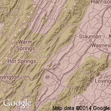
Saddle Gneiss named for Saddle Creek in southwestern part of Gossan Lead district, Grayson Co., southwestern VA. Well exposed at intersection of Saddle Creek and US Hwy 58. Best exposures at several places along US Hwy 58, on VA Hwy 95, and on US Hwy 21 south of its junction with VA Hwy 95. Saddle gneiss includes quartzite, biotite schist, gneiss, and garnetiferous facies with and without sillimanite. Quartzite in places contains graphite. Individual layers of these rocks, nowhere more than a few feet thick, alternate with each other in every outcrop to such an extent that different kinds of rock cannot be separately mapped. No sequence in rock determined. Garnetiferous biotite gneiss is medium- to fine-grained banded rock composed of fine quartz grains, grayish-green feldspar, and bronze biotite flakes. Highly garnetiferous facies occurs 1 mi east of Cattrons Mill. Quartzite abundant in Saddle gneiss in several narrow zones which lie north of and along US Hwy 58 from Baxter Ferry on New River southwestward to Independence. Quartzite layered with biotite gneiss is found chiefly in belt northwest of Fries overthrust and south of Striped Rock granite and north of Elk Creek village. Age is Precambrian. These are oldest known rocks of Gossan Lead district. Report includes geologic maps and cross sections.
Source: GNU records (USGS DDS-6; Reston GNULEX).
- Usage in publication:
-
- Saddle gneiss
- Modifications:
-
- Revised
- AAPG geologic province:
-
- Piedmont-Blue Ridge province
Summary:
Saddle gneiss included in Virginia Blue Ridge complex.
Source: GNU records (USGS DDS-6; Reston GNULEX).
- Usage in publication:
-
- Saddle Gneiss
- Modifications:
-
- Revised
- Age modified
- AAPG geologic province:
-
- Piedmont-Blue Ridge province
Summary:
Saddle Gneiss of Watauga Massif, Cranberry-Mine Layered Gneiss and Shoals [sic] Gneiss of Elk River Massif, and Low-Water-Bridge Gneiss (new) of Sauras Massif are all similar to Stage Road Layered Gneiss and in similar fashion all represent country rock intruded by Grenville-age plutonic rocks. Country rocks are generally about 1200 to 1100 Ma [Middle Proterozoic]. Authors abandon [Virginia] Blue Ridge Complex to which Saddle Gneiss was assigned.
Source: Modified from GNU records (USGS DDS-6; Reston GNULEX).
For more information, please contact Nancy Stamm, Geologic Names Committee Secretary.
Asterisk (*) indicates published by U.S. Geological Survey authors.
"No current usage" (†) implies that a name has been abandoned or has fallen into disuse. Former usage and, if known, replacement name given in parentheses ( ).
Slash (/) indicates name conflicts with nomenclatural guidelines (CSN, 1933; ACSN, 1961, 1970; NACSN, 1983, 2005, 2021). May be explained within brackets ([ ]).