

- Usage in publication:
-
- Sacaton formation*
- Modifications:
-
- Named
- Dominant lithology:
-
- Conglomerate
- AAPG geologic province:
-
- Basin-and-Range province
Summary:
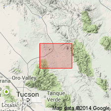
Named as upper formation of Gila group for exposures near Sacaton Ranch, about 12 mi southeast of Mammoth, Pinal Co, AZ in Basin-and-Range province. No type locality designated. Is disconformable on Quiburis formation of Gila group. Unconformably underlies Quaternary alluvial deposits. Correlation chart. Geologic map. Block diagrams. Composed of unconsolidated granule to pebble conglomerate made up of feldspar and quartz fragments. Also has fragments of diabase, graywacke, and phyllite. Matrix is sand and some silt. Weakly cemented by lime. Best developed on west side of San Pedro Valley. Maximum thickness of about 250 ft. Has a basal boulder to pebble gravel as much as 20 ft thick that has subround to well-rounded fragments of quartz monzonite, volcanic rocks, Paleozoic limestone, red calcareous mudstone, marble, and gneiss. Laid down in a broad valley cut into the Quiburis formation. Considered Pleistocene.
Source: GNU records (USGS DDS-6; Denver GNULEX).
- Usage in publication:
-
- Sacaton Formation†
- Modifications:
-
- Abandoned
Summary:
Sacaton Formation, upper formation of Gila Group of Heindl (1963), is abandoned. Gila geographically restricted from Ray-San Manuel area, eastern Pinal County, Arizona (Basin-and-Range province). Recent mapping shows deposition occurred after inception of the present drainage along the Gila and San Pedro Rivers and not during development of one large structural basin as previously thought. Rocks are here included in unnamed Pleistocene and Holocene gravel, and pediment gravel and soil units.
Source: Publication; Changes in stratigraphic nomenclature, 1972 (USGS Bull. 1394-A, p. A55).
For more information, please contact Nancy Stamm, Geologic Names Committee Secretary.
Asterisk (*) indicates published by U.S. Geological Survey authors.
"No current usage" (†) implies that a name has been abandoned or has fallen into disuse. Former usage and, if known, replacement name given in parentheses ( ).
Slash (/) indicates name conflicts with nomenclatural guidelines (CSN, 1933; ACSN, 1961, 1970; NACSN, 1983, 2005, 2021). May be explained within brackets ([ ]).