

- Usage in publication:
-
- S O volcanics*
- Modifications:
-
- Named
- Dominant lithology:
-
- Volcanics
- AAPG geologic province:
-
- Pedregosa basin
Summary:
Pg. 8, 110-115, pl. 5. S O volcanics. Thick series of interbedded quartz latite tuffs and hornblende andesite flows. Highly variable both laterally and vertically. Broadly divisible into three members. Basal member, series of quartz latite tuffs, breccias, and minor obsidian flows, with interbedded conglomerates, sandstones, and mudstones also largely of pyroclastic origin; thickness ranges from 1,600 feet on southeast face of Stockton Hill to knife edge just across valley to the south, and is missing within about a mile in that direction. Intermediate member, hornblende andesite flows, probably about 1,000 feet thick east of S O Ranch and about 300 feet thick south of Reeves Ranch. Upper member, quartz latite tuff, with a few local intercalations of true rhyolite and hornblende andesite; thickness about 1,100 feet on Hay Mountain, elsewhere much less. Hornblende andesite flow member apparently the most uniform and continuous part of formation. Accumulated upon older erosion surface of considerable relief so that in various localities different members lie at stratigraphic base of formation and overlie various formations including Gleeson quartz monzonite (new) and Bisbee formation. Underlies undeformed late Quaternary alluvium at most localities. Probably not older than Miocene and early Pliocene seems an upper age limit for this volcanism. Report includes geologic map.
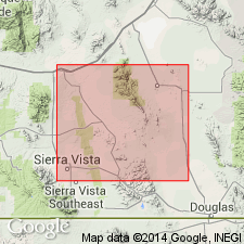
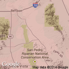
Exposed near S O Ranch, in sec. 20, T. 20 S., R. 24 E., Benson and Pearce quadrangles, central Cochise Co., southeastern AZ. Well exposed between south end of Hay Mountain and the hills southwest of Reeves Ranch, about 8 mi to northwest. Other bodies occur south of Cowan Ranch, near Outlaw Mountain, on pediment extending northwest of Outlaw Mountain, and on west side of Dragoon Mountains near Bar O Ranch. Named from S O Ranch.
Source: US geologic names lexicon (USGS Bull. 1200, p. 3650-3651).
- Usage in publication:
-
- S O Volcanics*
- Modifications:
-
- Geochronologic dating
- AAPG geologic province:
-
- Pedregosa basin
Summary:
Sample collected from a quartz latite tuff in S O Volcanics in the Dragoon Mountains, AZ, Lat. 31 deg. 44 min. N., Long. 109 deg. 53 min. W. Age is Tertiary. K-Ar age on biotite 47 +/-2 Ma.
Source: Modified from GNU records (USGS DDS-6; Denver GNULEX).
- Usage in publication:
-
- S O Volcanics*
- Modifications:
-
- Age modified
- Geochronologic dating
- AAPG geologic province:
-
- Pedregosa basin
Summary:
Samples collected from S O Volcanics in the Dragoon Mountains and vicinity, Cochise Co., AZ. Age changed from Miocene or Pliocene --to-- Eocene. Recalculated K-Ar age is 48 +/-2 Ma.
Source: Modified from GNU records (USGS DDS-6; Denver GNULEX).
- Usage in publication:
-
- S O Volcanics*
- Modifications:
-
- Age modified
- AAPG geologic province:
-
- Pedregosa basin
Summary:
Middle member shown as of Oligocene and Miocene age. Upper and lower members shown as of Paleocene, Eocene, Oligocene, and Miocene age. Correlation chart. Is in the Dragoon Mountains, Cochise Co, AZ in the Pedregosa basin.
Source: GNU records (USGS DDS-6; Denver GNULEX).
For more information, please contact Nancy Stamm, Geologic Names Committee Secretary.
Asterisk (*) indicates published by U.S. Geological Survey authors.
"No current usage" (†) implies that a name has been abandoned or has fallen into disuse. Former usage and, if known, replacement name given in parentheses ( ).
Slash (/) indicates name conflicts with nomenclatural guidelines (CSN, 1933; ACSN, 1961, 1970; NACSN, 1983, 2005, 2021). May be explained within brackets ([ ]).