

- Usage in publication:
-
- Rush Creek Member
- Modifications:
-
- Original reference
- AAPG geologic province:
-
- Strawn basin
Summary:
(See also C.F. Dodge, 1969, Texas Jour Sci., v. 21, no. 4, p. 49; C.F. Dodge, 1969, Texas Jour. Sci., v. 21, no. 1, p. 43-62; C.F. Dodge, 1952, Field and Lab., v. 20, no. 2, p. 69-70.) Rush Creek Member of Woodbine Formation. Two new member names proposed for the Woodbine. Rush Creek below and Arlington above. [Age is Late Cretaceous.]
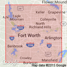
Area of report is Tarrant Co., north-central TX.
Source: US geologic names lexicon (USGS Bull. 1350, p. 647).

- Usage in publication:
-
- Rush Creek Member
- Modifications:
-
- Principal reference
- Dominant lithology:
-
- Sand
- Clay
- AAPG geologic province:
-
- Strawn basin
Summary:
Pg. 334-335 (credited to C.F. Dodge, Univ. Texas-Arlington, May 1970). Rush Creek Member of Woodbine Formation. Sand and clay. Thickness 12.2 feet. Underlies Dexter Member of Woodbine; unconformably overlies Grayson Formation. Called basal clays by Taff (1893, Texas Geol. Survey Ann. Rpt.) and basal clay member by Dodge (1952, Field and Lab., v. 20, no. 2). Age is Late Cretaceous (Gulfian). Recognized in north and northeastern Texas.
Type locality: stream bank on Rush Creek, about 0.7 mi southeast of the east end of the dam at Lake Arlington, in southeast Tarrant Co., north-central TX.
Source: Publication.
For more information, please contact Nancy Stamm, Geologic Names Committee Secretary.
Asterisk (*) indicates published by U.S. Geological Survey authors.
"No current usage" (†) implies that a name has been abandoned or has fallen into disuse. Former usage and, if known, replacement name given in parentheses ( ).
Slash (/) indicates name conflicts with nomenclatural guidelines (CSN, 1933; ACSN, 1961, 1970; NACSN, 1983, 2005, 2021). May be explained within brackets ([ ]).