

- Usage in publication:
-
- Roundtop group
- Modifications:
-
- Named
- Dominant lithology:
-
- Shale
- Mudstone
- Limestone
- AAPG geologic province:
-
- Chadron arch
- Denver basin
Summary:
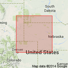
Named Roundtop group. These rocks were previously assigned to Division V of Hartville formation [not used in this report] in earlier reports. Recognized in sections near the Hartville uplift, Wyoming, and in the Black Hills of South Dakota, on the Chadron arch. Composed of alternating beds of greenish-gray, sandy, finely micaceous shale; gray to purple red, mottled, calcareous, massive mudstone; and light-gray to greenish-gray, fossiliferous limestone. Is up to 149 feet thick. Overlies Reclamation group (new); underlies Hayden group (new). Correlated with the Cherokee group of Des Moines series. Age is Pennsylvanian. Report includes measured sections.
Named from Roundtop Mountain, sec. 22, T. 27 N., R. 66 W. (also the type locality), Platte Co., WY, in the Denver basin.
Source: Modified from GNU records (USGS DDS-6; Denver GNULEX).
- Usage in publication:
-
- Roundtop group
- Modifications:
-
- Areal extent
- Overview
- AAPG geologic province:
-
- Powder River basin
Summary:
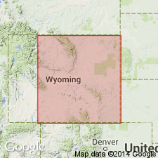
Combined with underlying Reclamation group to form a subdivision of Hartville formation in the subsurface, along the east side of Powder River basin in Niobrara, Weston, Crook, and Campbell Counties, Wyoming. /Reclamation-Roundtop groups overlie Fairbank formation and underlie the combined /Meek-Wendover and Hayden groups, all considered subdivisions of the Hartville formation. Correlated with the lower part of the lower division of Casper formation in the Laramie Mountains, Wyoming, and with the lower part of Tensleep sandstone in the Bighorn Mountains, Wyoming. Age is Middle Pennsylvanian (early Desmoinesian).
[The use of a hyphen between undifferentiated [groups] has not been considered proper notation since 1933 (see CSN, Art. 13a, p. 437-438). Where the [groups] have not been separated in the field, it is considered proper notation to add the word "and", "undifferentiated", "included", etc.; and list [groups] in order of age (youngest first).]
Source: Modified from GNU records (USGS DDS-6; Denver GNULEX).
- Usage in publication:
-
- Roundtop group
- Modifications:
-
- Areal extent
- Overview
- AAPG geologic province:
-
- Williston basin
Summary:
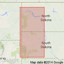
Used in formational sense in Williston basin. Consists of predominately red, green, and brown waxy shales interbedded with very thin beds of dolomite. Mapped in combination with underlying Reclamation group and Fairbank(?) [formation]. Formerly included at top of Amsden formation by the North Dakota Geological Society (1954, Stratigraphy of the Williston basin). Age is probably Middle Pennsylvanian (Desmoinesian); see correlation chart (table 2, p. 151).
Source: Modified from GNU records (USGS DDS-6; Denver GNULEX).
For more information, please contact Nancy Stamm, Geologic Names Committee Secretary.
Asterisk (*) indicates published by U.S. Geological Survey authors.
"No current usage" (†) implies that a name has been abandoned or has fallen into disuse. Former usage and, if known, replacement name given in parentheses ( ).
Slash (/) indicates name conflicts with nomenclatural guidelines (CSN, 1933; ACSN, 1961, 1970; NACSN, 1983, 2005, 2021). May be explained within brackets ([ ]).