The National Geologic Map Database is migrating to a new infrastructure. We apologize for any service disruptions during this process.
|
|---|


- Usage in publication:
-
- Rosarito Beach Formation
- Modifications:
-
- Named
- Dominant lithology:
-
- Basalt
- Sandstone
- Siltstone
- AAPG geologic province:
-
- Peninsular Ranges province
Summary:
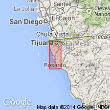
Subdivided in Mexico into western block with Mira al Mar and Costa Azul Members and eastern block with Amado Nervo, Las Glorias, and Los Buenos Members. Type section: for Mira al Mar Member is located 0.5 mi south of Rancho Mira al Mar; for Costa Azul Member is 300 ft east of Rancho Jose; for Amado Nervo Member is 1.75 mi south of Escuela Amado Nervo near Agua Caliente Fault; for Las Glorias Member is designated as exposures on both sides of Agua Caliente Fault near La Gloria; and for Los Buenos Member type section is west of Escuela Los Buenos on north side of Canyon, all in Tijana-Rosarito Beach area, Baja California, Mexico. Consists of basalt flows and interbedded sandstone, siltstone, mudstone, and bentonitic claystone. Is 360 m thick. Overlies Eocene rocks; unconformably underlies San Diego Formation. Is Miocene and Pliocene age based on fossil casts identified by W.O. Addicott (written commun., 1966).
Source: GNU records (USGS DDS-6; Menlo GNULEX).
- Usage in publication:
-
- Rosarito Beach Formation
- Modifications:
-
- Age modified
- Biostratigraphic dating
- Geochronologic dating
- AAPG geologic province:
-
- Peninsular Ranges province
Summary:
K-Ar age determinations (Jim Hawkins, 1969, oral commun.) yielded age of 14.3 +/-2.6 Ma for lower part of Costa Azul Member of Rosarito Beach Formation. New fossil localities near top of formation in tuffaceous sandstone include TURRITELLA OCOYANA and ANADARA TOPANGENSIS (W.O. Addicott, 1967, written commun.) which indicate middle Miocene age.
Source: GNU records (USGS DDS-6; Menlo GNULEX).
- Usage in publication:
-
- Rosarito Beach Formation
- Modifications:
-
- Areal extent
- Revised
- Age modified
- AAPG geologic province:
-
- Peninsular Ranges province
Summary:
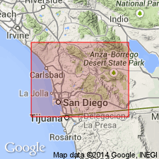
Proposed that names Sweetwater and Otay be given member status in Rosarito Beach Formation in California because rocks are similar and of same age as those in Mexico. Type section for Sweetwater Member designated as exposures between Acacia Avenue and Otay Lakes Road in Bonita along south side of Sweetwater Valley. Type section for Otay Member designated as natural amphitheater on northeast side of Chester Canyon opposite bentonite clay mine. San Diego Co, CA. Age of Sweetwater Member is changed from Eocene to Miocene because coarse clastic facies of Sweetwater is totally dissimilar from those of Eocene age.
Source: GNU records (USGS DDS-6; Menlo GNULEX).
- Usage in publication:
-
- Rosarito Beach Formation
- Modifications:
-
- Areal extent
- Revised
- AAPG geologic province:
-
- Peninsular Ranges province
Summary:
Confirmed correlation between Otay Formation (Artim and Pinckney, 1973) (previously thought to be part of Pliocene San Diego Formation) with Minch's (1970) Rosarito Beach Formation. Proposed abandoning name Otay and extending name Rosarito Beach to include Miocene strata in southwestern San Diego County. Rosarito Beach Formation thins northward from 76+ m east of Tijuana to 0 m north of Sweetwater Valley in southwestern San Diego County. Disconformably overlies Sweetwater Formation in area mapped.
Source: GNU records (USGS DDS-6; Menlo GNULEX).
For more information, please contact Nancy Stamm, Geologic Names Committee Secretary.
Asterisk (*) indicates published by U.S. Geological Survey authors.
"No current usage" (†) implies that a name has been abandoned or has fallen into disuse. Former usage and, if known, replacement name given in parentheses ( ).
Slash (/) indicates name conflicts with nomenclatural guidelines (CSN, 1933; ACSN, 1961, 1970; NACSN, 1983, 2005, 2021). May be explained within brackets ([ ]).