The National Geologic Map Database is migrating to a new infrastructure. We apologize for any service disruptions during this process.
|
|---|


- Usage in publication:
-
- Romana Sandstone*
- Modifications:
-
- Named
- Dominant lithology:
-
- Sandstone
- AAPG geologic province:
-
- Plateau sedimentary province
Summary:
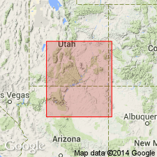
Named for Romana Mesa, north side of Lake Powell, as the upper formation of San Rafael Group in Kaiparowits basin, Kane Co, UT, Plateau sedimentary province. Type section 44.2 m thick measured and described on northeast side of Crosby Canyon, SE1/4 NE1/4 SE1/4 sec 8, T43S, R4E. Previously referred to as gray sandstone unit and as sandstone at Romana Mesa. Is a very fine- to fine-grained, moderately to well-sorted, flat-bedded and cross-bedded, gray sandstone. Can be as much as 4.6 m thick. Contains scattered coarse and very coarse grains at or near base. These grains are valuable in distinguishing Romana from Entrada which usually lacks coarse constituents. Small chert pebbles concentrated along some of bedding planes. Flat-bedded red mudstone or silty sandstone, called the red band, is a convenient basal marker locally. Is limited to Kaiparowits basin and Plateau sedimentary province, northernmost Coconino Co, AZ. Overlies Entrada Sandstone; underlies Tidwell (new) or Salt Wash Members of Morrison unconformably. Correlates [chart] with Summerville Formation. Deposited in or along margin of a narrow seaway. Interpreted as a southern or southwestern facies of the Summerville. Cross-beds of eolian strata dip east.
Source: GNU records (USGS DDS-6; Denver GNULEX).
For more information, please contact Nancy Stamm, Geologic Names Committee Secretary.
Asterisk (*) indicates published by U.S. Geological Survey authors.
"No current usage" (†) implies that a name has been abandoned or has fallen into disuse. Former usage and, if known, replacement name given in parentheses ( ).
Slash (/) indicates name conflicts with nomenclatural guidelines (CSN, 1933; ACSN, 1961, 1970; NACSN, 1983, 2005, 2021). May be explained within brackets ([ ]).