

- Usage in publication:
-
- Rocky Hill basalt
- Modifications:
-
- First used
- AAPG geologic province:
-
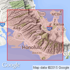
- Oahu
Summary:
Rocky Hill basalt mapped in Tantalus-Roundtop district, [Honolulu quad] Island of Oahu. Composed of coarse ash, agglomerate and rhyoclastic lava.
Source: GNU records (USGS DDS-6; Menlo GNULEX).
- Usage in publication:
-
- Rocky Hill volcanics*
- Modifications:
-
- Named
- Dominant lithology:
-
- Basalt
- AAPG geologic province:
-
- Oahu
Summary:
Named for occurrence at Rocky Hill, largest of 4 cinder cones in Tantalus-Roundup district, Island of Oahu. Formerly in part called Rocky Hill basalt by Wentworth (1926). Included in Honolulu volcanic series. Composed of cinder cones and lava flows. Rocky Hill cone is 130 ft above adjacent land, but base is not exposed. Underlies Sugar Loaf basalt (new). Tentatively assigned to the Kaena stand of sea. Assigned middle(?) and late Pleistocene age.
Source: GNU records (USGS DDS-6; Menlo GNULEX).
- Usage in publication:
-
- Rocky Hill volcanics*
- Modifications:
-
- Age modified
- AAPG geologic province:
-
- Oahu
Summary:
Exposed over area of about 0.1 sq mi in lower end of Manoa Valley on south side of Koolau Range about 11 mi west of Makapuu Head. No fossils. Assigned Pleistocene age based on stratigraphic relationships, deep weathering, and tentative assignment to plus 95-ft (Kaena) stand of sea.
Source: GNU records (USGS DDS-6; Menlo GNULEX).

- Usage in publication:
-
- Rocky Hill Volcanics†
- Modifications:
-
- Abandoned
- AAPG geologic province:
-
- Oahu
Summary:
Rocky Hill Volcanics (Stearns, IN Stearns and Vaksvik, 1935) abandoned as formally named unit and renamed Rocky Hill flow (and associated cones), informal unit of Honolulu Volcanics.
Source: GNU records (USGS DDS-6; Menlo GNULEX).
For more information, please contact Nancy Stamm, Geologic Names Committee Secretary.
Asterisk (*) indicates published by U.S. Geological Survey authors.
"No current usage" (†) implies that a name has been abandoned or has fallen into disuse. Former usage and, if known, replacement name given in parentheses ( ).
Slash (/) indicates name conflicts with nomenclatural guidelines (CSN, 1933; ACSN, 1961, 1970; NACSN, 1983, 2005, 2021). May be explained within brackets ([ ]).