The National Geologic Map Database is migrating to a new infrastructure. We apologize for any service disruptions during this process.
|
|---|


- Usage in publication:
-
- Rocky Gulch Sandstone Member*
- Modifications:
-
- Named
- Dominant lithology:
-
- Sandstone
- Shale
- Siltstone
- AAPG geologic province:
-
- Klamath Mountains province
Summary:
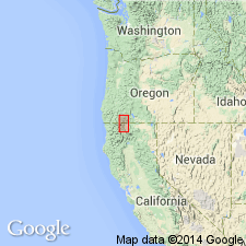
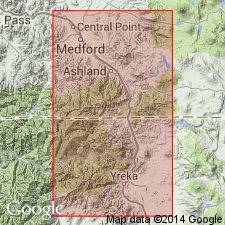
Is second from uppermost member of Hornbrook Formation. Named for outcrops in Rocky Gulch about 2 km southwest of Hornbrook. Type section designated as exposures in road cuts along northbound lane of HWY I-5 adjacent to and west of Klamath River (NE/4 NE/4 sec.32 T47N R6W, Hornbrook 15' quad, Siskiyou Co, CA). Consists chiefly of beds of gray, fine- and medium-grained sandstone that are either amalgamated or separated by thin shale intervals; locally, conglomerate, and siltstone are present. Generally 115 to 225 m thick (171 m at type); appears to be locally absent on south flank of Black Mountain. Appears to conformably and gradationally overlie Ditch Creek Siltstone Member (new) (Hornbrook Formation) except at type where contact is erosional. Conformably underlies Blue Gulch Mudstone Member (new) (Hornbrook Formation). Age is Campanian based on foraminifers (identified by W.V. Sliter) from shale interbeds southeast of Medford.
Source: GNU records (USGS DDS-6; Menlo GNULEX).
- Usage in publication:
-
- Rocky Gulch Sandstone Member*
- Modifications:
-
- Age modified
- Overview
- AAPG geologic province:
-
- Klamath Mountains province
Summary:
Strata of Rocky Gulch Sandstone Member were mapped by Wells (1956) as Eocene Umpqua Formation, by McKnight (1971) as Payne Cliffs Formation, and by Smith and others (1982) as Tertiary nonmarine strata. However, on basis of foraminiferal faunas, petrography, and character of sedimentary sequences these rocks are properly assigned to Rocky Gulch Sandstone Member of Hornbrook Formation. [Thus unit geographically extended into parts (Copco 15' and Medford 15' quads) of report area where not previously recognized.] Measured type section, detailed lithology, depositional environment, and mapping included in report. Single collection of foraminifers yields middle Turonian age, but member probably ranges in age from middle Turonian to Campanian(?) age.
Source: GNU records (USGS DDS-6; Menlo GNULEX).
For more information, please contact Nancy Stamm, Geologic Names Committee Secretary.
Asterisk (*) indicates published by U.S. Geological Survey authors.
"No current usage" (†) implies that a name has been abandoned or has fallen into disuse. Former usage and, if known, replacement name given in parentheses ( ).
Slash (/) indicates name conflicts with nomenclatural guidelines (CSN, 1933; ACSN, 1961, 1970; NACSN, 1983, 2005, 2021). May be explained within brackets ([ ]).