The National Geologic Map Database is migrating to a new infrastructure. We apologize for any service disruptions during this process.
|
|---|


- Usage in publication:
-
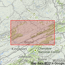
- Rockdell limestone
- Modifications:
-
- Named
- Dominant lithology:
-
- Limestone
- AAPG geologic province:
-
- Appalachian basin
Summary:
Named the Rockdell limestone for Rockdell, Russell Co., southwestern VA. Consists of coarse-grained, light gray, high-calcium limestone with a few beds of dark gray, cherty limestone. Thickness is 100 to 300 feet. Unit overlies the Lincolnshire limestone and underlies the Benbolt limestone; it correlates with the Perry and Ward Cove limestones of Tazewell Co. The name Rockdell is used where the Perry and Ward Cove cannot be differentiated. Along the base of Clinch Mountain, the upper two-thirds of the Rockdell is dark gray granular cherty limestone and lower part is coarse-grained, light gray and free from chert; in Rosedale belt, the upper part is nodular-weathering earthy limestone containing NIDULITES and the lower part is light gray, pinkish, coarse-grained limestone with a clastic texture. The Rockdell is of Middle Ordovician age.
Source: GNU records (USGS DDS-6; Reston GNULEX).
- Usage in publication:
-
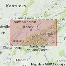
- Rockdell Formation
- Modifications:
-
- Revised
- Areal extent
- AAPG geologic province:
-
- Appalachian basin
Summary:
Geographically extended the Rockdell to eastern TN and revised to the Rockdell Formation of the Chickamauga Group. Predominantly consists of light gray, skeletal grainstones and interspersed patches of lime wackestones that comprise three gradational lithofacies: 1) pelmatozoan-bryozoan grainstone-packstone, 2) pelmatozoan-bryozoan packstone, and 3) bryozoan wackestone. Unit overlies the Lincolnshire Formation and underlies the Benbolt Formation or Holston Formation. It is the fourth formation up, within the Chickamauga Group. Thickness is nearly 100 meters in the central part of the study area, but thins to the west and east.
Source: GNU records (USGS DDS-6; Reston GNULEX).
For more information, please contact Nancy Stamm, Geologic Names Committee Secretary.
Asterisk (*) indicates published by U.S. Geological Survey authors.
"No current usage" (†) implies that a name has been abandoned or has fallen into disuse. Former usage and, if known, replacement name given in parentheses ( ).
Slash (/) indicates name conflicts with nomenclatural guidelines (CSN, 1933; ACSN, 1961, 1970; NACSN, 1983, 2005, 2021). May be explained within brackets ([ ]).