

- Usage in publication:
-
- Rivil subinterval
- Modifications:
-
- Overview
- Dominant lithology:
-
- Limestone
- Anhydrite
- AAPG geologic province:
-
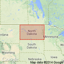
- Williston basin
Summary:
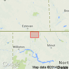
Pg. 1, 4 (fig. 3), 5-12. Rivil subinterval (informal) in uppermost part of Frobisher-Alida interval (informal) of Madison group. Defined by mechanical-log markers. Present in subsurface of the Williston basin, North Dakota. Consists of (from west to east) pelletoidal limestone, oolitic and pelletoidal limestone with common secondary anhydrite, and interbedded anhydrite and sucrosic limestone. Corresponds to the lower part of the Midale beds (as redefined by the Saskatchewan Geological Society, 1956). Thickness averages about 40 feet; ranges from about 30 feet on east side of area to about 50 feet on the west. In Rivil field consists of oolitic and fragmental limestone, underlain by a few feet of anhydrite overlain by . Underlies Midale subinterval (informal) of Ratcliffe interval (informal) of Madison group (= Midale beds of Anderson and Carlson, 1958); overlies lower part of Frobisher-Alida interval. Age is Mississippian. Mechanical-log boundaries shown for the Pan American, B. Staaleson No. 1 well, in NW/4 NE/4 sec. 6, T. 162 N., R. 91 W., Burke Co., ND, and in five mechanical-log cross sections in Burke Co., ND.
Named from producing interval in Rivil oil field, Burke Co., ND, by [M. H. Smith, 1960, "Revised nomenclature for the Williston basin [abs.]," Billings, MT, AAPG Rocky Mountain Section, 10th Ann. Mtg. Prog. w/ Abs. ]. Type locality not designated.
Source: Publication; GNU records (USGS DDS-6; Denver GNULEX).
- Usage in publication:
-
- Rivil subinterval
- Modifications:
-
- Overview
- AAPG geologic province:
-
- Williston basin
Summary:
Rivil subinterval (informal) in upper part of Frobisher-Alida interval (informal) of Madison group. Defined by mechanical-log markers. Present in subsurface of the Williston basin, North Dakota. Consists of 25 to 30 feet of anhydrite and dolomitic limestone. Changes facies [westward] in Burke County to oolitic limestone. Underlies Midale subinterval (informal) of Ratcliffe interval (informal) of Madison group; overlies upper limestone unit of Frobisher-Alida interval. Age is Mississippian. Electric-log characteristics shown for the Carter-Phillips G. Blower No. 1 well, in SE/4 SW/4 sec. 20, T. 160 N., R. 83 W., Bottineau Co., ND, and on a detailed electric- and radioactivity-log correlation diagram extending from Renville Co., ND, southward to Sioux Co., ND.
Source: Modified from GNU records (USGS DDS-6; Denver GNULEX).
- Usage in publication:
-
- Rivil subinterval
- Modifications:
-
- Overview
- AAPG geologic province:
-
- Williston basin
Summary:
Rivil subinterval (informal) in upper part of Frobisher-Alida interval (informal) of Madison Group. Defined by mechanical-log markers. Present in subsurface of the Williston basin, North Dakota. Compares usage of the term by some previous authors in North Dakota and southeastern Saskatchewan. Summarizes lithologic and stratigraphic relations. Age is early Late Mississippian (early Meramecian), based on correlation with equivalent rocks in Canada. Electric-log characteristics shown for the Carter Oil Company, E.L. Semling No. 1 well, in sec. 18, T. 141 N., R. 81 W., Oliver Co., ND.
Source: Modified from GNU records (USGS DDS-6; Denver GNULEX).
For more information, please contact Nancy Stamm, Geologic Names Committee Secretary.
Asterisk (*) indicates published by U.S. Geological Survey authors.
"No current usage" (†) implies that a name has been abandoned or has fallen into disuse. Former usage and, if known, replacement name given in parentheses ( ).
Slash (/) indicates name conflicts with nomenclatural guidelines (CSN, 1933; ACSN, 1961, 1970; NACSN, 1983, 2005, 2021). May be explained within brackets ([ ]).