

- Usage in publication:
-
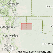
- Rita Blanca deposits
- Modifications:
-
- Overview
- Areal extent
- AAPG geologic province:
-
- Palo Duro basin
Summary:
Are mapped east of Rita Blanca Creek in southeastern Hartley Co, TX (Palo Duro basin), TX panhandle. Map unit described to be comprised of upper and lower parts. Upper part: sand, bentonitic clay, and thin-bedded calcareous sandstone; thickness 50 ft or more. Lower part: dark, distinctly laminated clay, some interbeds of sand and thin uniform layers of nonmarine dolomite; fossils include plants and small fish; thickness 30 ft or more. Assigned to the Pleistocene.
Source: GNU records (USGS DDS-6; Denver GNULEX).
For more information, please contact Nancy Stamm, Geologic Names Committee Secretary.
Asterisk (*) indicates published by U.S. Geological Survey authors.
"No current usage" (†) implies that a name has been abandoned or has fallen into disuse. Former usage and, if known, replacement name given in parentheses ( ).
Slash (/) indicates name conflicts with nomenclatural guidelines (CSN, 1933; ACSN, 1961, 1970; NACSN, 1983, 2005, 2021). May be explained within brackets ([ ]).