The National Geologic Map Database is migrating to a new infrastructure. We apologize for any service disruptions during this process.
|
|---|


- Usage in publication:
-
- Risco formation
- Modifications:
-
- Original reference
- Dominant lithology:
-
- Graywacke
- Sandstone
- AAPG geologic province:
-
- San Joaquin basin
Summary:
Pg. 7 (fig. 3), 12-16, pls. 2, 3. See also 1956 [abs.], Dissert. Abs., v. 16, no. 1, p. 101. Risco formation. Massive greenish-gray concretionary graywacke, forming rugged cliffs; lower half contains six tuffaceous sandstones; conglomerate present at base of formation west of Polonio Pass fault. At type locality, formation is roughly divisible into three parts in approx. thickness ratio (from bottom to top) of 2:3:5. Upper and lower parts consists of massive concretionary coarse sandstone, sandwiching a group of thin finer-grained sandstones relatively free of concretions. Roughly the same ratio holds in Three Peaks anticline, despite thinning and facies change. Thickness 2,965 feet at type locality; 4,400 feet north of Antelope pumping station; 1,650 in Three Peaks anticline; thinning is toward the northeast; unit pinches out on north limb of Three Peaks anticline. Conformably underlies Johnson Peak formation (new); overlies Badger shale (new), at type locality, contact is a thrust, but elsewhere contact is conformable. No diagnostic fossils. Age is Late Cretaceous(?).
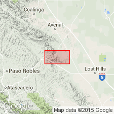
Type locality: comprises upper parts of both Risco Canyon and next adjacent canyon to the west, west of Orchard Peak, Annette quadrangle, Kern Co., southern CA. Formation extends as nearly continuous band of outcrop from northwest corner of Orchard Peak area southeastward, then eastward almost to Devil's Den where it ends abruptly against Hex thrust.
Source: US geologic names lexicon (USGS Bull. 1200, p. 3287).
- Usage in publication:
-
- Risco Formation
- Modifications:
-
- Overview
- AAPG geologic province:
-
- San Joaquin basin
Summary:
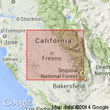
zzzzzArea of report is Avenal Ridge-Reef Ridge area of southern Diablo Range, 200 miles southeast of San Francisco, in Fresno and Kings Counties, west-central California. Eight stratigraphic units ranging from Early to Late Cretaceous are recognized in area, in descending [ascending?] order: Badger Shale, Risco Formation, Johnson Peak Formation, Catskin Formation (new), Lovel Shale (new), Redman [Red Man] Sandstone, Willow Spring Mudstone (new), and Moreno Formation. All rocks are marine of shallow neritic to bathyl depths and consist of thick sequences of mudstone, shale, thin- to thick-bedded concretionary sandstones and conglomerates. Unconformities exist between [Red Man] (Campanian) and Willow Spring (Maastrichtian); [Red Man] and Lovel (Santonian); and Lovel and Catskin (Cenomanian to Coniacian).
Source: US geologic names lexicon (USGS Bull. 1350, p. 130, 443, 832); supplemental information from GNU records (USGS DDS-6; Menlo GNULEX).
For more information, please contact Nancy Stamm, Geologic Names Committee Secretary.
Asterisk (*) indicates published by U.S. Geological Survey authors.
"No current usage" (†) implies that a name has been abandoned or has fallen into disuse. Former usage and, if known, replacement name given in parentheses ( ).
Slash (/) indicates name conflicts with nomenclatural guidelines (CSN, 1933; ACSN, 1961, 1970; NACSN, 1983, 2005, 2021). May be explained within brackets ([ ]).