

- Usage in publication:
-
- Rio Grande loess
- Modifications:
-
- Original reference
- Dominant lithology:
-
- Loess
- AAPG geologic province:
-
- Estancia basin
Summary:
Pg. 26-43. Rio Grande loess. [Name applied to lower part of Rio Grande series.] Sandy loess passing into clay, depth not known, but recognized everywhere. [Age is late Tertiary.]
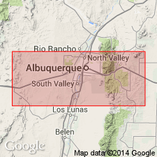
[Notable exposures in environs of Albuquerque, central northern NM.]
Source: US geologic names lexicons (USGS Bull. 896, Rio Grande series entry p. 1816-1817).
- Usage in publication:
-
- Rio Grande loess
- Modifications:
-
- Not used
- AAPG geologic province:
-
- Estancia basin
Summary:
The term "Rio Grande loess" was applied by Herrick to the portion of Rio Grande beds exposed underneath the Rio Grande gravels. The term does not seem applicable, for reason that these stratified silts and sands can hardly be called loess.
Source: US geologic names lexicon (USGS Bull. 896, p. 1817).
For more information, please contact Nancy Stamm, Geologic Names Committee Secretary.
Asterisk (*) indicates published by U.S. Geological Survey authors.
"No current usage" (†) implies that a name has been abandoned or has fallen into disuse. Former usage and, if known, replacement name given in parentheses ( ).
Slash (/) indicates name conflicts with nomenclatural guidelines (CSN, 1933; ACSN, 1961, 1970; NACSN, 1983, 2005, 2021). May be explained within brackets ([ ]).