

- Usage in publication:
-
- Rincon formation
- Modifications:
-
- Original reference
- Dominant lithology:
-
- Shale
- AAPG geologic province:
-
- Ventura basin
Kerr, P.F., 1931, Bentonite from Ventura, California: Economic Geology, v. 26, no. 2, p. 153-168.
Summary:
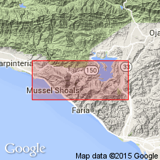
Pg. 156, 157. Rincon formation. A sequence of gray shale containing concretionary dolomitic layers, underlying the bentonite bed at base of Modelo formation in Ventura quadrangle, and overlying Vaqueros formation. Thickness 2,150 feet as exposed in a type section along Los Sauces Creek east of Rincon Mountain, Ventura County, coastal region southern California. [Age is early or middle Miocene.]
Source: US geologic names lexicon (USGS Bull. 896, p. 1815).
- Usage in publication:
-
- Rincon formation
- Modifications:
-
- Areal extent
- AAPG geologic province:
-
- Ventura basin
Summary:
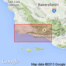
Pg. 50. Rincon formation. Is a well-defined stratigraphic unit that can be traced along the coast for nearly 100 miles. Consists essentially of dark-gray clay shale or mudstone, which commonly contains concretions of impure yellow limestone and carries Foraminiferas of late lower or early middle Miocene age. Thickness 300 to 2,000 feet. Underlies Modelo formation and overlies Vaqueros formation.
Source: US geologic names lexicon (USGS Bull. 896, p. 1815).
- Usage in publication:
-
- Rincon shale
- Modifications:
-
- Areal extent
- AAPG geologic province:
-
- Ventura basin
Summary:
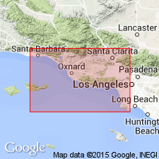
Pl. 2. Showed Rincon shale as (1) underlying Modelo formation and overlying Vaqueros sandstone on southern slope of eastern Santa Ynez Range; (2) as in part equivalent to Topanga formation in Santa Clara and Simi Valleys, and as both underlain and overlain by Topanga deposits. He stated (personal commun.) that in his opinion Rincon and Topanga formations are two distinct facies, with distinct faunas, and that the Rincon facies is not present in type Topanga, but that it includes time equivalent of at least part of the Topango and of upper part of Vaqueros. [Age is early or middle Miocene.]
Source: US geologic names lexicon (USGS Bull. 896, p. 1815).
For more information, please contact Nancy Stamm, Geologic Names Committee Secretary.
Asterisk (*) indicates published by U.S. Geological Survey authors.
"No current usage" (†) implies that a name has been abandoned or has fallen into disuse. Former usage and, if known, replacement name given in parentheses ( ).
Slash (/) indicates name conflicts with nomenclatural guidelines (CSN, 1933; ACSN, 1961, 1970; NACSN, 1983, 2005, 2021). May be explained within brackets ([ ]).