

- Usage in publication:
-
- Rife Bed*
- Modifications:
-
- Named
- Dominant lithology:
-
- Oil-shale
- Dolomite
- Siltstone
- Mudstone
- Tuff
- AAPG geologic province:
-
- Green River basin
Summary:
Named as upper bed of Tipton Shale Member (of Tipton Tongue where overlain by Cathedral Bluffs Tongue of Wasatch Formation) of Green River Formation for Rife Ranch. Formerly considered informal bed at base of Wilkins Peak Member of Green River. Type section designated, measured SW1/4 sec 13, NW1/4 sec 24, T13N, R103W, Sweetwater Co, WY. Present central, southwest, southeast parts of Greater Green River basin of southwest WY and northwest CO. Not deposited west part of basin. Conformably overlies Scheggs Bed (new), basal bed of Tipton Shale Member (or Tongue), Farson Sandstone Member (new) of Green River, Alkali Creek Tongue (new) of Wasatch. Underlies, intertongues with Wilkins Peak Member of Green River. Rife and Scheggs conformable across south and east parts of Greater Green River basin, but never in contact central part of basin and along northwest flank of Rock Springs uplift; Scheggs and Rife separated by Farson on northwest flank of uplift. 149+ ft thick at type; usually ranges 25-150 ft thick; maximum thickness 315 ft. Consists of dark-brown to gray-brown dolomitic oil-shale, tan-gray to gray-brown, very hard, dense dolomite, gray-green to -brown, blocky to platy dolomitic mudstone, tan-brown, dolomitic, platy, hard siltstone at type. Has thin, white to gray tuff. Oil shale beds replaced by mudstone at basin margins. Saltwater, lacustrine deposit of late early Eocene age. Cross section, areal extent map, columnar section.
Source: GNU records (USGS DDS-6; Denver GNULEX).
- Usage in publication:
-
- Rife Bed*
- Modifications:
-
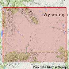
- Areal extent
- Overview
- AAPG geologic province:
-
- Green River basin
Summary:
Isopach map (fig 22) shows areal extent within Greater Green River basin, WY and CO. Rife (Tipton Shale Member of Green River Formation) deposited in lake that occupied an area 150 mi long and 100 mi wide; deepest part of lake located along Uinta Mountain trough. Locally more than 200 ft thick in three places: 1) southeast part of Green River basin; 2) southwest part of Washakie basin; and 3) south-central part of Great Divide basin. Rife is less than 100 ft thick across most of Rock Springs uplift and southern Green River basin; was not deposited in northern and central parts of Green River basin, in southeast part of Washakie basin, and in most of Sand Wash basin. Stratigraphic chart; cross sections. Eocene age.
Source: GNU records (USGS DDS-6; Denver GNULEX).

- Usage in publication:
-
- Rife Bed*
- Modifications:
-
- Overview
- AAPG geologic province:
-
- Green River basin
Summary:
Paleogeographic map (fig. 53) of this bed of Tipton Shale Member of Green River Formation showing depositional environments in Greater Green River basin. Consists of mostly dark-brown to black, high-grade oil shale deposited in offshore parts of Lake Gosiute; thickest intervals of oil shale exceed 200 ft and occur along trend of Uinta Mountain trough. Algal reefs were abundant in shallow nearshore waters of lake, thin sand beaches were present along lake shores, and most backshore areas consisted of mudflats; flood-plain and arkosic sediments continued to be deposited at outer margins of basin. Lake Gosiute contracted to area of Uinta Mountain trough occupying an area of about 7,000 sq mi for about 500,000 yr. Overlies Scheggs Bed of Tipton with sharp contact; boundary coincides with an abrupt change to hotter and drier climate, closing of outlet of Lake Gosiute, and an abrupt change in lake waters from fresh to saline. Underlies Wilkins Peak Member of Green River or Cathedral Bluffs Tongue of Wasatch Formation. Generalized stratigraphic chart (fig. 41). Mapped (fig. 1), combined with Wilkins Peak, in Vermilion Creek area, northwest CO. Eocene age.
Source: GNU records (USGS DDS-6; Denver GNULEX).
For more information, please contact Nancy Stamm, Geologic Names Committee Secretary.
Asterisk (*) indicates published by U.S. Geological Survey authors.
"No current usage" (†) implies that a name has been abandoned or has fallen into disuse. Former usage and, if known, replacement name given in parentheses ( ).
Slash (/) indicates name conflicts with nomenclatural guidelines (CSN, 1933; ACSN, 1961, 1970; NACSN, 1983, 2005, 2021). May be explained within brackets ([ ]).