

- Usage in publication:
-
- Riepetown sandstone
- Modifications:
-
- Named
- Dominant lithology:
-
- Sandstone
- AAPG geologic province:
-
- Great Basin province
Summary:
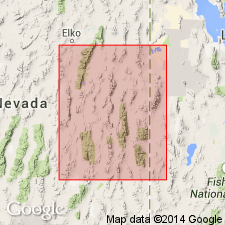
Pg. 93 (chart 1), 103. Riepetown sandstone. Name applied to basal sandstone member of Pennebaker's (1932) †"Rib Hill" formation (herein abandoned). Thickness 1,008 feet at type locality where it consists of pale yellowish-gray, very fine- to medium-grained, rounded to subrounded, platy to thick-bedded quartz sandstone which weathers brownish red and yellowish tan, with interbedded gray, silty limestones. Overlies Riepe Spring limestone (new); underlies Arcturus formation of Leonardian age. At Moorman Ranch, Riepetown is about 1,200 feet thick, conformably overlies Riepe Spring limestone and underlies Moorman Ranch facies of Pequop formation. Outcrops distributed over an area of about 25,000 sq. mi. (see areal extent map); extends into Utah. Hose and Repenning (1959) did not apply "Rib Hill" to beds in Confusion Range, but used Lawson's Arcturus limestone for those rocks stratigraphically above Riepe Spring limestone (= their Ely) and below Kaibab formation. Upper 700 feet nonfossiliferous. Basal 300 feet yielded fusulinids SCHWAGERINA LINEARIS and PSEUDOSCHWAGERINA aff. P. TEXANA, indicating a late Wolfcampian age. Contains a variety of gastropods, pelecypods, ostracods, some sharks teeth. Report includes correlation chart.
Type section: at Rib Hill, in NW/4 sec. 21, T. 16 N., R. 62 E., White Pine Co., NV (Great Basin province). Name derived from village of Riepetown, about 2 mi north-northwest of Rib Hill.
Source: US geologic names lexicon (USGS Bull. 1200, p. 3273): supplemental information from GNU records (USGS DDS-6; Denver GNULEX).
- Usage in publication:
-
- Riepetown Sandstone
- Modifications:
-
- Revised
- AAPG geologic province:
-
- Great Basin province
Summary:
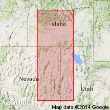
Revised in that Riepetown assigned as one of 4 formations of the Arcturus Group (rank raised) over an area extending from eastern NV into western UT in the Great Basin province. Riepetown is equivalent to the upper part of the Ferguson Mountain, a name applied where the lower part of the Arcturus cannot be divided. Riepetown overlies Riepe Spring Sandstone of Arcturus Group and underlies Pequop Formation of Arcturus. Detailed description of historic use. Nomenclature chart. Graphic section. Cross section. Of Wolfcampian, [Early] Permian age.
Source: GNU records (USGS DDS-6; Denver GNULEX).
For more information, please contact Nancy Stamm, Geologic Names Committee Secretary.
Asterisk (*) indicates published by U.S. Geological Survey authors.
"No current usage" (†) implies that a name has been abandoned or has fallen into disuse. Former usage and, if known, replacement name given in parentheses ( ).
Slash (/) indicates name conflicts with nomenclatural guidelines (CSN, 1933; ACSN, 1961, 1970; NACSN, 1983, 2005, 2021). May be explained within brackets ([ ]).