The National Geologic Map Database is migrating to a new infrastructure. We apologize for any service disruptions during this process.
|
|---|


- Usage in publication:
-
- Riepe Spring limestone
- Modifications:
-
- Named
- AAPG geologic province:
-
- Great Basin province
Summary:
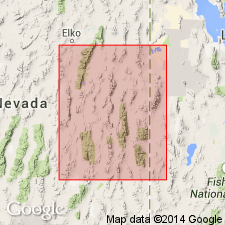
Pg. 93 (chart 1), 102. Riepe Spring limestone. Name given to ledge-forming, massive to medium-bedded, coralline and fusulinid-bearing limestones originally included in Ely limestone by Spencer (1917) and by Pennebaker (1932) but restricted from Ely in present paper at type locality. Extends into (see areal extent map) parts of adjacent Eureka, Nye, and Lincoln Counties, Nevada, and into western Millard and Beaver Counties, Utah, an area of approximately 8,000 sq. mi. At type locality, Riepe Spring is gray, micro- to finely crystalline limestone, 410 feet thick; underlain by South Ridge sandstone (new) and overlain by Riepetown sandstone (new). On north side of Rib Hill, in Ruth mining district, upper 300 feet of Ely limestone, as described by Spencer (1917), is assigned to Riepe Spring; here unit rests disconformably on Ely (restricted) with no development of South Ridge sandstone separating the formations. Recognized in Carbon Ridge area south of Eureka, unit is 618 feet thick and rests on unnamed sequence of calcareous silts and mudstones and is overlain by Riepetown sandstone. Beds here assigned to Riepe Spring, plus underlying silts and mudstones, and overlying sands of Riepetown and limestones of Pequop formation were named Carbon Ridge formation by Nolan (1956). Riepe Spring is present in Confusion Range, Utah, where it was included in Ely limestone by Hose and Repenning (1959). In Tooele County, Utah, overlies Oquirrh formation. Correlated with the Pakoon limestone of Arizona, Utah, Nevada, and with Kirkman limestone of Oquirrh basin. Age is Permian (Wolfcampian), based on fusulinids (listed). Colonial corals (listed) make up 10 percent of formation. Report includes correlation chart.
Type section: at north end of Ward Mountain, in SE/4 sec. 7, T. 15 N., R. 63 E., White Pine Co., NV. Named from Riepe Spring in SE/4 SE/4 sec. 36, T. 16 N., R. 62 E., Ely quadrangle.
Source: US geologic names lexicon (USGS Bull. 1200, p. 3272): supplemental information from GNU records (USGS DDS-6; Denver GNULEX).
- Usage in publication:
-
- Riepe Spring Limestone
- Modifications:
-
- Revised
- AAPG geologic province:
-
- Great Basin province
Summary:
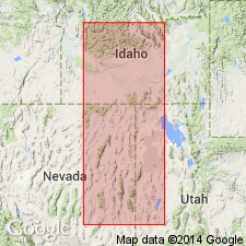
Revised in that Riepe Spring Limestone assigned as the basal formation of Arcturus Group (rank raised). Overlies Hogan Formation of Ely Group disconformably. Underlies Riepetown Formation of Arcturus Group. Chert-pebble conglomerate at base of Riepe Spring. Upper contact is a change from limestone to siltstone and sandstone of Riepetown. Nomenclature chart. Graphic section. Cross section. Detailed discussion on history of usage within its areal extent --eastern NV and western UT, Great Basin province. Of Wolfcampian, [Early] Permian age. Is equivalent to the lower part of the Ferguson Mountain Formation, basal formation of the Arcturus at Carlin Canyon and Ferguson Mountain, Elko Co., NV and in UT in the Gold Hill district, Tooele Co. and northern Confusion Range, Millard Co. where lower part of Arcturus divisible into two formations.
Source: GNU records (USGS DDS-6; Denver GNULEX).
For more information, please contact Nancy Stamm, Geologic Names Committee Secretary.
Asterisk (*) indicates published by U.S. Geological Survey authors.
"No current usage" (†) implies that a name has been abandoned or has fallen into disuse. Former usage and, if known, replacement name given in parentheses ( ).
Slash (/) indicates name conflicts with nomenclatural guidelines (CSN, 1933; ACSN, 1961, 1970; NACSN, 1983, 2005, 2021). May be explained within brackets ([ ]).