The National Geologic Map Database is migrating to a new infrastructure. We apologize for any service disruptions during this process.
|
|---|


- Usage in publication:
-
- Rice Formation
- Modifications:
-
- Named
- Dominant lithology:
-
- Sandstone
- Shale
- Arkose
- AAPG geologic province:
-
- Midcontinent region
Summary:
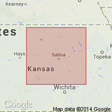
Pg. 380-384. The thick sequence of pre-Upper Cambrian feldspathic sandstone and shale in central Kansas can be distinguished from other material in Kansas called "granite wash" and is here named Rice Formation. Typically developed in Rice County where it is reported in 26 wells. Four typical drillholes designated rather than type well. In each of these holes the Reagan Sandstone overlies the Rice and underlies the Arbuckle Group. In basin east of Sixth Principal Meridian, 13 holes penetrate pre-Reagan sedimentary rocks that informally have been called Rice sedimentary group. Rice Formation is here substituted for the Rice sedimentary group. Composed of feldspathic sandstone, arkose, and red and green, sandy, micaceous shale. Cutting and core samples predominantly grayish-red to grayish-orange-pink, or rarely, dark-reddish-brown, fine-grained, feldspathic sandstone. Grains rounded to subangular and frosted. Greenish-gray and dark-reddish-brown shale interbedded with the sandstone. In drillhole no. 4, limestone and dolomite are interbedded with feldspathic sandstone and shale, but carbonate rocks are a minor constituent of formation. Marine depositional environment suggested. Top of Rice more than 3,600 feet below surface; bottom not reached, but thickness more than 1,000 feet. Occurs in north-central Kansas, chiefly in two northeast-trending subsurface basins [see areal map (fig. 1)]. Overlain by Upper Cambrian Reagan Sandstone; presumably underlain by crystalline Precambrian rocks. Age could be Cambrian or Precambrian. Precambrian(?) age suggested on basis of origin soon after regional metamorphism (dated at 1.0 to 1.2 b.y.).
Type section not designated. Four typical drillholes designated in: (1) sec. 32, T. 16 S., R. 8 W. (Ellsworth Co.); (2) sec. 14, T. 17 S., R. 9 W. (Ellsworth Co.); (3) sec. 24, T. 18 S., R. 8 W. (Rice Co.); and (4) sec. 22, T. 19 S., R. 9 W. (Rice Co.). Drillholes: Continental No. 3 "A" Hodgson, Ellsworth Co.; Empire No. 13 Rolfs, Ellsworth Co.; Continental No. 9 Ainworth, Rice Co.; and Bishop No. 5 Reese, Rice Co. [Unfortunately only the drillhole localities were compiled in GNU records (USGS DDS-6; Denver GNULEX) and only the drillhole names were compiled in US geologic names lexicon (USGS Bull. 1350). Sooooo --have to consult the paper to see what goes with what.] Named from Rice Co., KS where unit occurs in the subsurface in 26 wells, in the Midcontinent region.
Source: US geologic names lexicon (USGS Bull. 1350, p. 629); modified from GNU records (USGS DDS-6; Denver GNULEX).
- Usage in publication:
-
- Rice Formation
- Modifications:
-
- Overview
- AAPG geologic province:
-
- Midcontinent region
Summary:
(Precambrian rocks by E.D. Goebel, p. 11.) Rice Formation. Sedimentary rocks older than Late Cambrian age in Kansas are questionably assigned to the Precambrian. A thick sequence of these rocks in north-central Kansas has been distinguished by Scott (1966) from other material called "granite wash" and named "the Rice Formation" (Pl. 1). The formation occurs in a roughly triangular area between Marshall and Osborne counties on the north and Reno and Harvey counties on the south. The Rice Formation is composed of feldspathic sandstone, arkose, and red and green sandy micaceous shale and is unconformably overlain by the Lamotte Sandstone. The Rice is believed to rest upon Precambrian crystalline rocks. In Rice County, limestone and dolomite is interbedded with feldspathic sandstone and shale, but carbonate rocks are a minor constituent. Although the base of the formation has not been penetrated, the sequence locally exceeds 1,600 feet in thickness.
Source: Publication.
For more information, please contact Nancy Stamm, Geologic Names Committee Secretary.
Asterisk (*) indicates published by U.S. Geological Survey authors.
"No current usage" (†) implies that a name has been abandoned or has fallen into disuse. Former usage and, if known, replacement name given in parentheses ( ).
Slash (/) indicates name conflicts with nomenclatural guidelines (CSN, 1933; ACSN, 1961, 1970; NACSN, 1983, 2005, 2021). May be explained within brackets ([ ]).