- Usage in publication:
-
- Revard sandstone
- Modifications:
-
- First used
- Dominant lithology:
-
- Sandstone
- AAPG geologic province:
-
- Chautauqua platform
Summary:
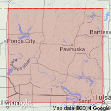
First published use in the Osage Reservation area, Osage Co, OK on the Chautauqua platform. Intent to name not stated. Type locality designated at Revard Point [source of name?], sec 13, T26N, R10E; a "good reference locality" designated on the bluff facing Bird Creek due east of the town of Quapaw, NE1/4 SE1/4 sec 36, T25N, R20E, where the top of the Revard is about 45 ft below top of the hill. Area of this report is in T25N, R10E, Osage Co; Revard is particularly prominent in southeastern part of this township. Consists of massive sandstone very similar to Cheshewalla sandstone (first used), with lentils of red shale; is 30 to 80 ft thick. The shale lentils vary in length from a few ft to a mile or more, and vary in thickness from a few inches to 6 ft. Lies about 145 ft below Labadie limestone. Locally, red shale directly overlies the Revard sandstone. Geologic maps. Stratigraphic sections. Of upper [Late] Pennsylvanian age.
Source: GNU records (USGS DDS-6; Denver GNULEX).
For more information, please contact Nancy Stamm, Geologic Names Committee Secretary.
Asterisk (*) indicates published by U.S. Geological Survey authors.
"No current usage" (†) implies that a name has been abandoned or has fallen into disuse. Former usage and, if known, replacement name given in parentheses ( ).
Slash (/) indicates name conflicts with nomenclatural guidelines (CSN, 1933; ACSN, 1961, 1970; NACSN, 1983, 2005, 2021). May be explained within brackets ([ ]).

