

- Usage in publication:
-
- Rencher formation
- Modifications:
-
- Named
- Dominant lithology:
-
- Conglomerate
- Sandstone
- Limestone
- Tuff
- Dacite
- Breccia
- AAPG geologic province:
-
- Great Basin province
Summary:
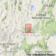
Probably named for exposures near Rencher Ranch at north end of Grass Valley, Washington Co, UT, Great Basin province. Type locality, though not specifically designated, probably near Rencher Ranch where unit is well exposed. Consists of basal units of red conglomerate, calcareous sandstone, and white lacustrine limestone which fill depressions in underlying Quichapa group (new); and gray to tan, biotitic, dacite welded tuff with abundant quartzite pebbles ("pebble tuff") which at type grades upward into poorly bedded, unsorted tuff-breccia which in turn grades to white massive, structureless, biotitic tuff. Rocks above basal units probably deposited during nuee ardente eruption. Near The Dairy and east to Paradise, Rencher contains unit of dacite porphyry breccia made up of gray blocks with bluish cast. In places a volcanic sandstone unconformably overlies dacite porphyry breccia or bedded tuff-breccia. Above dacite breccia and volcanic sandstone and locally resting on white tuff is a breccia of subangular fragments of hard, red-brown lithoidal latite? which forms cliffs above white tuff around Grass Valley. In places latite? breccia overlain by unbroken rock of same composition or by soft, white, bedded, lithic tuff. Thickness ranges up to 600 ft. Unconformably overlies Quichapa; unconformably (or in thrust fault contact) underlies Grass Valley formation (new). Geologic map; stratigraphic chart; cross sections. Assigned Tertiary age.
Source: GNU records (USGS DDS-6; Denver GNULEX).
- Usage in publication:
-
- Rencher formation
- Modifications:
-
- Contact revised
- AAPG geologic province:
-
- Great Basin province
Summary:
Lower contact revised in that the Rencher overlies the newly named Harmony Hills tuff [member] of the Quichapa formation (reduced in rank from group). Upper contact revised in that the Rencher underlies the newly named Irontown member of the Page Ranch formation. Of Oligocene-Miocene age. Report area lies in southwest UT in the Great Basin province.
Source: GNU records (USGS DDS-6; Denver GNULEX).
- Usage in publication:
-
- Rencher Formation*
- Modifications:
-
- Areal extent
- Geochronologic dating
- AAPG geologic province:
-
- Great Basin province
Summary:
A Miocene age composite ash-flow sheet in eastern Bull Valley Mountains, northern Pine Valley Mountains, and Iron Springs district of southwest UT, Great Basin province. Derived from Bull Valley intrusion. Younger than informal dacite of Pinon Park Wash; older than Pine Valley Latite. Composite stratigraphic column. K-Ar dates on biotite are reported as 23.6 +-0.7 Ma for lowest cooling unit; 21.8 +/-0.7 Ma for middle cooling unit; and 21.5 +-0.6 Ma for upper tuff-breccia flow unit. Date on lower unit is rejected because it is discordant with the other dates and is numerically older than probable age of underlying Harmony Hills Tuff.
Source: GNU records (USGS DDS-6; Denver GNULEX).
For more information, please contact Nancy Stamm, Geologic Names Committee Secretary.
Asterisk (*) indicates published by U.S. Geological Survey authors.
"No current usage" (†) implies that a name has been abandoned or has fallen into disuse. Former usage and, if known, replacement name given in parentheses ( ).
Slash (/) indicates name conflicts with nomenclatural guidelines (CSN, 1933; ACSN, 1961, 1970; NACSN, 1983, 2005, 2021). May be explained within brackets ([ ]).