The National Geologic Map Database is migrating to a new infrastructure. We apologize for any service disruptions during this process.
|
|---|


- Usage in publication:
-
- Reformatory granite
- Modifications:
-
- First used
- Dominant lithology:
-
- Granite
- AAPG geologic province:
-
- South Oklahoma folded belt
Taylor, C.H., 1915, Granites of Oklahoma: Oklahoma Geological Survey Bulletin, no. 20, 108 p.
Summary:
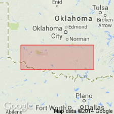
First published use; intent to name not stated. Present in the Granite area, and also in northwest part of Lugert area, Greer County, Oklahoma. Reformatory granite is a batholithic mass that intrudes the Headquarters granite (new) to the east of Headquarters Mountain, near Granite, Oklahoma. Reformatory is the most southern of the granites of this area. Following solidification, there were at least two periods of fracturing and intrusion of dikes. Fresh Reformatory granite is even, medium-grained, flesh-red, with flesh-colored feldspar, colorless to slightly smoky quartz and clusters of greenish-black hornblende and magnetite. Is cut by widely spaced, strong vertical joint systems bearing north-south, east-west, northeast-southwest, and northwest-southeast. Sheet joints are better developed in Reformatory than anywhere in the Wichita Mountains. Weathering is largely accomplished by changes of temperature and chemical decomposition, causing slabs 1 to 4 inches thick to exfoliate and then break down into a mass of feldspar and quartz crystals. Is younger than Headquarters granite (new) and older than Lugert granite (new). Age is pre-Middle Cambrian [based on the fact that all of the granites are overlain unconformably by the Reagan sandstone which, according to Ulrich (1904), is Middle Cambrian]. Age is Precambrian. Report includes geologic map.
Type locality not designated. Derivation of name not stated, but probably named from State Reformatory in Granite, Greer Co., OK, in Wichita Mountains district, S. Oklahoma folded belt province.
Source: Modified from GNU records (USGS DDS-6; Denver GNULEX).
For more information, please contact Nancy Stamm, Geologic Names Committee Secretary.
Asterisk (*) indicates published by U.S. Geological Survey authors.
"No current usage" (†) implies that a name has been abandoned or has fallen into disuse. Former usage and, if known, replacement name given in parentheses ( ).
Slash (/) indicates name conflicts with nomenclatural guidelines (CSN, 1933; ACSN, 1961, 1970; NACSN, 1983, 2005, 2021). May be explained within brackets ([ ]).