

- Usage in publication:
-
- Reef Trail Member*
- Modifications:
-
- Original reference
- Biostratigraphic dating
- Dominant lithology:
-
- Siltstone
- Mudstone
- AAPG geologic province:
-
- Permian basin
Summary:
Reef Trail Member of Bell Canyon Formation. Uppermost member of Bell Canyon. At type section consists of (ascending): (1) yellowish-weathering calcareous siltstone, 9 feet; (2) gray lime mudstone, 5 inches; (3) gray-weathering silty lime mudstone, 3 feet; (4) lime mudstone, 4.5 to 5 inches; (5) gray, silty lime mudstone, 4.5 feet; and (6) lime mudstone, 3 inches. Total thickness 18 feet. Overlies Lamar Limestone Member of Bell Canyon Formation. [Elsewhere, underlies Castile Formation and in western Glass Mountains, southwestern Texas, underlies Tessey Limestone.] Replaces informal "post-Lamar beds" of King (1948). Age is considered Middle to Late Permian (Guadalupian to Lopingian); fusulinid biozones REICHELINA and PARABOULTONIA.
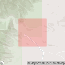
Type section (composite): beginning on small escarpment less than 0.5 mi northeast of Guadalupe National Park Visitors Center, McKittrick Canyon, and continuing to top of hill (5180 ft elev.), west of Park boundary line; [approx. Lat. 31 deg. 58 min. 51 sec. N., Long. 104 deg. 44 min. 44 sec. W., Independence Spring 7.5-min quadrangle, eastern edge Guadalupe Mountains National Park, Culberson Co., western TX; see Lambert and others (2010) entry]. Extends into Eddy Co., southern NM.
Named from nearby Geology Reef Trail at the Guadalupe National Park Visitors Center, McKittrick Canyon, Culberson Co., western TX.
Source: Publication.
- Usage in publication:
-
- Reef Trail Member*
- Modifications:
-
- Reference
- Age modified
- Biostratigraphic dating
- Adopted
- AAPG geologic province:
-
- Permian basin
Summary:
Reef Trail Member of Bell Canyon Formation. Reference section designated; is a more complete and continuous exposure than type. Subdivided into correlation intervals (descending): (4) silty carbonate mudstone with a few interbeds of wackestone and packstone, 6.37 m thick, carries fusulinacean PARABOULTONIA SPENDENS; (3) debris flow beds of packstone, 1.15 m thick, carries ammonoid STRIGOGONIATITES FOUNTAINI and fusulinacean PARABOULTONIA SPENDENS; (2) mostly covered interval of siltstone or fine sandstone, 4.81 m thick; and (1) siltstone or fine sandstone interbedded with wackstone turbidites and debris flow beds, 1.70 m thick. Overlies Lamar Limestone Member of Bell Canyon; underlies Castile Formation. Conodont JINOGONDOLELLA ALTUDAENSIS, recovered from the lower and upper parts of Reef Trail, indicates a latest Middle Permian (latest Guadalupian; latest Capitanian) age. (Reef Trail Member of Bell Canyon Formation of Delaware Mountain Group adopted by the USGS.)
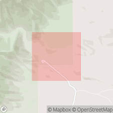
Reference section: about 200 m southeast of type section, McKittrick Canyon, from Lat. 31.9796 deg. N., Long. 104.7446 deg. W. to Lat. 31.9802 deg. N., Long. 104.7443 deg. W. (WGS 1984 projection), Independence Spring 7.5-min quadrangle, eastern edge Guadalupe Mountains National Park, Culberson Co., western TX, [approx. Lat. 31 deg. 58 min. 47 sec. N., Long. 104 deg. 44 min. 39 sec. W.].
Location of type section: Lat. 31.9809 deg. N., Long. 104.7457 deg. W. (WGS 1984 projection), Independence Spring 7.5-min quadrangle, eastern edge Guadalupe Mountains National Park, Culberson Co., western TX, [approx. Lat. 31 deg. 58 min. 51 sec. N., Long. 104 deg. 44 min. 44 sec. W.].
Source: Publication.
For more information, please contact Nancy Stamm, Geologic Names Committee Secretary.
Asterisk (*) indicates published by U.S. Geological Survey authors.
"No current usage" (†) implies that a name has been abandoned or has fallen into disuse. Former usage and, if known, replacement name given in parentheses ( ).
Slash (/) indicates name conflicts with nomenclatural guidelines (CSN, 1933; ACSN, 1961, 1970; NACSN, 1983, 2005, 2021). May be explained within brackets ([ ]).