

- Usage in publication:
-
- Red Draw Member*
- Modifications:
-
- Named
- Dominant lithology:
-
- Shale
- Siltstone
- Sandstone
- AAPG geologic province:
-
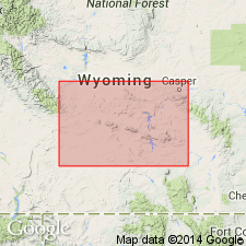
- Green River basin
Summary:
Named as basal member of Jelm Formation of Chugwater Group (rank raised) for Red Draw, Carbon Co, WY in Greater Green River basin. Type section designated in NW1/4 NW1/4 sec 25, NE1/4 sec 26, T24N, R80W. Is about 100 ft thick at type section where it consists of reddish-brown shale, siltstone, and sandstone. Makes lime-cemented ripple-marked ledges. Thins from type to about 35 ft at Bell Springs in sec 9, T23N, R88W and cannot be recognized northwest of this point. Is about 140 ft thick at Red Mountain. Contact with underlying Alcova Limestone (rank raised) of Chugwater gradational at some localities and is probably disconformable at other localities. Underlies Sips Creek Member (new) of Jelm. Of Triassic age. Cross sections. Columnar sections.
Source: GNU records (USGS DDS-6; Denver GNULEX).
- Usage in publication:
-
- Red Draw Member*
- Modifications:
-
- Areal extent
- AAPG geologic province:
-
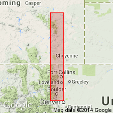
- Denver basin
Summary:
As a member of Upper Triassic Jelm Formation extends from north of Mesa Mountains, Laramie Co, WY south to Little Thompson, Boulder Co, CO, all in Denver basin. Wedges out between Horse Creek and Mesa Mountain in WY and between Little Thompson and Four Mile Canyon in CO. Is exclusively a salmon-pink, calcareous, cross-bedded sandstone. Measured sections shown graphically. Underlies Sundance Formation unconformably. Overlies Lykins Formation unconformably in CO. Underlies Red Peak Formation of Chugwater Group unconformably in WY.
Source: GNU records (USGS DDS-6; Denver GNULEX).
For more information, please contact Nancy Stamm, Geologic Names Committee Secretary.
Asterisk (*) indicates published by U.S. Geological Survey authors.
"No current usage" (†) implies that a name has been abandoned or has fallen into disuse. Former usage and, if known, replacement name given in parentheses ( ).
Slash (/) indicates name conflicts with nomenclatural guidelines (CSN, 1933; ACSN, 1961, 1970; NACSN, 1983, 2005, 2021). May be explained within brackets ([ ]).